The Mediterranean route into Europe (Paschou et al. 2014)

How can you have peace when everybody attacks you?

Yes, those bloody monarchies should have been completely obliterated.

Feed the queen now.

I don't

any many attack because they have nationalistic ideas ( I can forgive these nuff nuffs) that they where brought up with...........propaganda fed people
 
I started this thread to discuss the Mediterranean route of the Neolithic into Europe. I enjoy some little digressions as much as the next person, maybe more, but this diatribe against Napoleon is totally off topic, in my opinion. That is one of the rules of the forum, isn't it? To stay on topic?

I wonder if there's also a rule about attacking a member's ethnicity or nation at every turn? Just asking.
 
I don't

any many attack because they have nationalistic ideas ( I can forgive these nuff nuffs) that they where brought up with...........propaganda fed people

I suggest you be clearer in your statements and use right and concise structure.

There are those of us who aren't natives, and do not understand some dubious arguments.
 
I would appreciate it if a moderator could remove the off-topic argument from the thread so we can get back to discussing the diffusion of the Neolithic by a sea route. Of course, I don't mean anything that has to do with varying sea levels in the Mediterranean, as that would be pertinent.
 
This is the National Geographic's take on the paper.
http://news.nationalgeographic.com/...ng-europe-islands-genetics-neolithic-science/

There's also some quotes from the authors:

Ed. Sorry, the quotes didn't post...
"The gene flow was from the Near East to Anatolia, and from Anatolia to the islands," Stamatoyannopoulos said. "How well the genes mirror geography is really striking."

The new data show that people living around the Mediterranean today have common ancestors in Anatolia. But then the genes diverge, with Greek islands like the Dodecanese archipelago and Crete forming a sort of genetic bridge to the rest of Greece, Sicily, Italy, and north into Europe. In the southern Mediterranean, the genetic signatures of modern-day Egyptians, Libyans, Tunisians, and Moroccans form a separate genetic branch.
The two distinct paths suggest that there wasn't much genetic mingling once the populations went their separate ways north and south from Anatolia. The sea helped migration in the northern Mediterranean, where people traveled by water from island to island as they spread west. But "there's very little gene flow" between the northern and southern Mediterranean, and "the sea served as a barrier," Stamatoyannopoulos said.

That's a pretty novel use of the term Near Eastern. They're definitely saying it went from the Levant to Anatolia and then to the islands, which I wasn't clear about from looking at all the tables in the supplement. It remains to be seen what ancient DNA will say.

The article also quotes from other scholars who have a slightly different take on the issue.

Those populations may not have been completely separate, however, said archaeologist Helen Dawson, a research fellow at the Topoi Excellence Cluster in Berlin who has excavated Neolithic sites on Mediterranean islands. There is evidence of contact across the Mediterranean: For example, archaeologists have found blades in Neolithic settlements in Tunisia made from volcanic glass that comes from isolated islands near Sicily.
"There could have been all sorts of networks across the Mediterranean that haven't left traces" in the genetic record, she said. "Maybe there was no genetic mixing, but there was definitely contact ... It's not like the sea posed an insurmountable barrier."

Also, Pontus Skoglund also chimed in...
Pontus Skoglund, a geneticist at Harvard Medical School, said more data are needed to confirm that these people accurately represent those who lived there 9,000 or more years ago. "This is a great initiative to look at these things more closely," he said. "The question is, what time depth does it have?"

Ideally, researchers would be able to compare ancient DNA recovered from the bones of Neolithic settlers to that of modern populations. "It's always difficult to make inferences mostly based on contemporary DNA," Skoglund cautioned. "Modern patterns are not necessarily representative of ancient patterns."


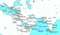
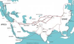

 
The question was in regard to why there would be a line going directly from Egypt to Sicily, (and Crete for that matter) but not to other parts of Italy. The fact that Egyptian galleys regularly supplied Rome with grain through the port of Ostia was a given. (See Post #10..."I would have to check on the shipping lanes at that time, to see if the grain ships from Egypt stopped to pick up additional grain in Sicily.") My speculation was that perhaps those galleys sometimes stopped in Sicily for additional grain, with Sicily acting as a sort of hub, although I have read nothing to that effect.

None of that has anything to do with the route those galleys had to take, which it is very well documented was not a route directly from Egypt to Italy. The wind and sea currents and the nature of navigation at that time precluded that route. Those same water and wind currents affected sea navigation far back into prehistory.

As to slavery, it is indeed true that there were some Egyptian slaves, and Egyptians living in Rome, and Romans living in Egypt, and as a result undoutedly some admixture. My point was that I don't see anything that is Sicily specific, the way that there is with documented Egyptian influence in Crete.

The Alexandria-Rome shipping route was in fact one of the most important ones in the empire, and it did not have to necessarily stop in Sicily.

http://www2.ferrum.edu/dhowell/rel113/pauls_journey/pathway.htm
 

Attachments

  • alex1.gif
    alex1.gif
    11 KB · Views: 69
  • Transasia_trade_routes_1stC_CE_gr2.jpg
    Transasia_trade_routes_1stC_CE_gr2.jpg
    36.5 KB · Views: 66
I tried to explain that these steps never see the sunlight again,
Angela found very good explanation to Venice sinking in post 33. I heard same thing 20 years ago in some documentary about this sinking city.
 
Ideally, researchers would be able to compare ancient DNA recovered from the bones of Neolithic settlers to that of modern populations. "It's always difficult to make inferences mostly based on contemporary DNA," Skoglund cautioned. "Modern patterns are not necessarily representative of ancient patterns."
Definitely we have to wait for the full story to be uncovered in ancient DNA.

On distinction of Sardinia admixtures. I don't know Sardinian history, but perhaps Sardinia was always on a poor side, not very attractive to conquerors, and thanks to this population survived fairly intact? Just a thought.


I agree that it's been poor for a very long time. However, throughout the Neolithic, the Copper, and the Bronze Ages, it was right in the center of the trade for minerals and the manufacture of metals.
This Wiki article on mining in Sardinia isn't bad.
http://en.wikipedia.org/wiki/History_of_mining_in_Sardinia

Mines of Sardinia:
SardegnaSaltoDiGessa.gif


See also the Abealzu-Filigosa Copper Age culture of Sardinia, dated to 2700-2400 BC
http://en.wikipedia.org/wiki/Abealzu-Filigosa_culture


See also:Nuragic Sardinia
http://en.wikipedia.org/wiki/Nuragic_civilization
(The Nuragic civilization was a civilization of Sardinia, lasting from the Bronze Age (18th century BC) to the 2nd century AD. The name derives from its most characteristic monuments, the nuraghe. They consist of tower-fortresses, built starting from about 1800 BC.[1]

All of this, and yet the Sardinians have very low levels of ANE, with a good proportion of it doubtless brought by more recent emigrants from Corsica and the mainland . If ANE can serve in the European context as a marker of Indo-European miners and/or metal smiths of the Copper Age and Bronze Age, then why do the Sardinians have such an incredibly low incidence of it? Why also, archaeologically, as is the case with recent discoveries in Spain, are the links to the Levant?
yep, tough cookie. Obviously Sardinia was of no vital interest to Indo Europeans. (if they were the main carrier of ANE into Europe.) I'll read up about this Nuragic civilization, maybe something will come out.
 
Yes, I know. So I've said...twice.


Thanks for the links, though.

You also implied that it was a nearly impossible voyage in Roman times and that the Mediterranean acted more as a barrier than land-travel would. Hardly so, in fact it was a very common trade route on which Rome depended greatly. It was easier to make such voyages through the Mediterranean than having to do them through land.
 
You also implied that it was a nearly impossible voyage in Roman times and that the Mediterranean acted more as a barrier than land-travel would. Hardly so, in fact it was a very common trade route on which Rome depended greatly. It was easier to make such voyages through the Mediterranean than having to do them through land.

The Romans were able to make the trip because they built huge ships and powered them with slaves. Even then, there was a particular route they needed to follow in order to make the trip. I think it would have been a very difficult journey in small vessels that relied solely on sail and couldn't tack against the wind. And yet the DNA evidence may suggest some spread of peoples around the Mediterranean during the Neolithic. I personally think at this point it's still a bit of an unsolved puzzle but that if we're going to get clearer answers to how people spread into southern Europe during the Neolithic we may need to look at the potential for crossings from Libya to Sicily and from Morocco to Spain.

Although of course some of the people who arrived in Europe during the Neolithic got there by skirting the Adriatic.
 
Last edited:
You also implied that it was a nearly impossible voyage in Roman times and that the Mediterranean acted more as a barrier than land-travel would. Hardly so, in fact it was a very common trade route on which Rome depended greatly. It was easier to make such voyages through the Mediterranean than having to do them through land.


I don't know whose posts you've been reading, but they certainly weren't mine...
 
I agree that it's been poor for a very long time. However, throughout the Neolithic, the Copper, and the Bronze Ages, it was right in the center of the trade for minerals and the manufacture of metals.
See also:Nuragic Sardinia
http://en.wikipedia.org/wiki/Nuragic_civilization
(The Nuragic civilization was a civilization of Sardinia, lasting from the Bronze Age (18th century BC) to the 2nd century AD. The name derives from its most characteristic monuments, the nuraghe. They consist of tower-fortresses, built starting from about 1800 BC.[1]

All of this, and yet the Sardinians have very low levels of ANE, with a good proportion of it doubtless brought by more recent emigrants from Corsica and the mainland . If ANE can serve in the European context as a marker of Indo-European miners and/or metal smiths of the Copper Age and Bronze Age, then why do the Sardinians have such an incredibly low incidence of it? Why also, archaeologically, as is the case with recent discoveries in Spain, are the links to the Levant?

It's intriguing how yDNA I2, which would be the "European natives", is concentrated around pre-historic mining areas - Sardinia, the Dinaric Alps, the Harz mountains. I don't know how well Asturias / Northern Portugal has been tested, but I would also guess for quite an "European natives" element there. The Romans clearly had a distaste for miner's work, regarded as labour for slaves, and that may reflect a general IE attitude. You trade with these people, maybe extract tribute from them, but you don't try to take over their business. Since they pay you off, you also don't pillage their villages and rape their women (they may anyway hide somewhere underground when foreign troops arrive). OTOH, obsidian or metal trade makes food import possible, and thus provides the "natives" with a regular nutritional base that supports population growth.
The mountainous areas allow for a bit of cattle grazing (rather sheep and goats than cows), but are fairly uninteresting to farmers, and about the last places the ANE would settle permanently. So, the "native" gene pool survives in considerably numbers.

As to Mediterranean sea levels and currents: An important factor is isostatic pressure. Glaciers locally push down the underlying plates, which rise correspondingly in non-ice-covered areas. When the glaciers recede, the formerly ice-covered areas rise, but non ice-covered grounds recede (you can try it out on every air-filled ball). The effect was very pronounced, and is still going on at reduced levels, in the North Sea, where the ground sunk substantially with the recess of Scottish and Norwegian glaciers. I am not aware to which extent the Dinaric Alps and the Italian Apennine were ice-covered during the LGM, but similar effects of sea-bottom lowering may have occurred in the Adriatic, to a lesser extent also the Tyrrhenian Sea. As such, sea levels, and with them water currents, may have locally differed substantially during the Neolithic from today. Cold inflow of glacier melt may also have locally affected salinity, sea currents and winds.

Moreover: http://en.wikipedia.org/wiki/Mount_Etna
Thousands of years ago, the eastern flank of the mountain experienced a catastrophic collapse, generating an enormous landslide in an event similar to that seen in the 1980 eruption of Mount St. Helens. The landslide left a large depression in the side of the volcano, known as 'Valle del Bove' (Valley of the Ox). Research published in 2006 suggested this occurred around 8000 years ago, and caused a huge tsunami, which left its mark in several places in the eastern Mediterranean. It may have been the reason the settlement of Atlit Yam (Israel), now below sea level, was suddenly abandoned around that time.
Finally, there have been various climate changes over the last 10,000 years that affected temperatures, rainfall and of course winds, sea-levels and currents of the Mediterranean. Check for detail here: http://en.wikipedia.org/wiki/Timeline_of_environmental_history; http://en.wikipedia.org/wiki/Subboreal
Holocene_Temperature_Variations.png


In short, the Mediterranean climate, water levels, winds and currents should have been substantially different during the Neolithic from today and also antiquity, and I wouldn't dare to conclude from today's patterns on possible setting routes during the Neolithic. Also, Egypt's population may have been quite different before climate refugees from the Libyan desert arrived there in the 6th millennium BC.
Note furthermore that before the first Punic War, Sicily and Sardinia were controlled by Cartago, which suggests the possibility of trans-Mediterranean travel during the iron age.
 
These two papers may be pertinent to the discussion. They place the geographical spread of farming in Europe into climate history. The derived expansion maps (through Anatolia and then via Crete and Southern Italy/ Sicily) are consistent to the genetic data and (most of) the archaeological record. In the second paper (map on p.5) I noted that their climate-based simulation has Southern Sardinia and the Iberian peninsula (except Catalonia) as European latecomers (on a scale with Sweden, but behind England, Germany and Denmark). They also mention climate fluctuations hindering agricultural development in the central Balkans. I need to look at both papers in more detail myself.
http://arheologija.ff.uni-lj.si/documenta/pdf36/36_5.pdf
http://www.academia.edu/1452222/On_...pean_Neolithic_transition_to_climate_extremes
This should be interesting read, thanks.
 
For anyone interested in navigation in the ancient world and its effect on the diffusion of people and culture not only in the Neolithic but in the Bronze and Iron Ages, I highly recommend this paper. It incorporates sea and wind current information, an analysis of navigational "tools", archaeological data, and historical references.

Davis, Navigation In the Ancient Eastern Mediterranean
http://anthropology.tamu.edu/papers/Davis-MA2001.pdf

There is an interesting discussion in the paper specifically of Neolithic navigation. "If we accept Tzalas's informed theory that the vessels of the Neolithic were likely composed of ...primitive materials (the product of a Neolithic toolkit) then we may safely infer that they were rowed or paddled; some had to have been able to handle heavy cargoes of domesticated animals, especially in colonizing efforts as Broodbank has shown...Although Mediterranean currents are often considered negligible, it is as well to note that Neolithic paddled craft, at their slow rate of travel, would have been greatly affected by even slight currents. And thus adjustments had to be made even when transiting from point to point over short stretches. When faced with an open sea crossing in the Aegean or the Levantine basin, Neolithic seafarers were at a distinct disadvantage if inclement weather or even moderate seas and winds developed, for they apparently lacked sails for convenient directional control and likely retained a low freehold."

The following quote is apropos to the Bronze Age:

"Dropping the question of sailing technology and weather patterns for a minute, let us consider that merchant ships of the Late Bronze Age simply rowed directly from Egypt to Crete. While there is little doubt that the largest vessels possessed sufficient oars for limited maneuvering near shore and in harbors, the actual energy to move a ship filled with several tons of cargo any significant distance against a constant, ten-knot headwind, is difficult to imagine. Moreover, the distance is more than 350 nautical miles, so it cannot be compared to rowing in the Aegean."

As to the Graeco-Roman period...
"We need look no further than parallels from the Graeco-Roman period, when ships with sailing rigs and hull shapes much improved over their Bronze Age forerunners nevertheless opted for the counter-clockwise route from Egypt to the Aegean...because weather and currents combined to make this route much more safe and less damaging to the ship and its equipment."

From: Roman Civilization-Selected Readings"
http://books.google.com/books?id=G0...gyptian grain ships en route to Ostia&f=false

"The Grain Fleet: The two selections given here are our most detailed ancient descriptions of the vessels of the Alexandrian grain fleets and of the routes by which they reached Italy. The usual route was to follow the prevailing winds north to Asia Minor, thence west via Crete to Malta, and then north to Puteoli or Ostia." The trip from southern Italy to Egypt was much faster and safer.
That makes sense : Levante - > Asia Minor -> Crete -> Malta -> Sicily / Southern Italy (possibly also Tunisia). Too bad Malta wasn't sampled.. OTOH, on an island as small as Malta, the returning Crusaders could have left quite a specific genetic mark...
 
That makes sense : Levante - > Asia Minor -> Crete -> Malta -> Sicily / Southern Italy (possibly also Tunisia).

The trail also seems to go up into the Balkans from Greece.

I think this map is generally correct in terms of chronology. I should point out, however, that I haven't checked the date of each site. I think there's also a pretty good correlation with the conclusions of this paper. This is the link so that you can decide for yourself the reliability you want to assign to it.
http://www.markbwilson.com/album/1-...a-Neolithic Agricultural Revolution Sites.jpg

2a-Neolithic%20Agricultural%20Revolution%20Sites.jpg


Some other interesting reading in terms of this paper:

Obsidian routes in the ancient Near East from 16,000 B.C. -6500 B.C.
http://www.archatlas.org/ObsidianRoutes/ObsidianRoutes.php
This is mostly a series of maps. I was particularly interested to see the "exchange route" linking Cappadoccia and the Levant. I have to check on what other information might be presented.

http://www.academia.edu/393048/Obsidian_Trade_and_Society_in_the_Central_Anatolian_Neolithic
I haven't yet read this one, but I will.
 

This thread has been viewed 66725 times.

Back
Top