Uninhabited areas added on Y-DNA maps

Maciamo

Veteran member
Admin
Messages
10,000
Reaction score
3,311
Points
113
Location
Lothier
Ethnic group
Italo-celto-germanic
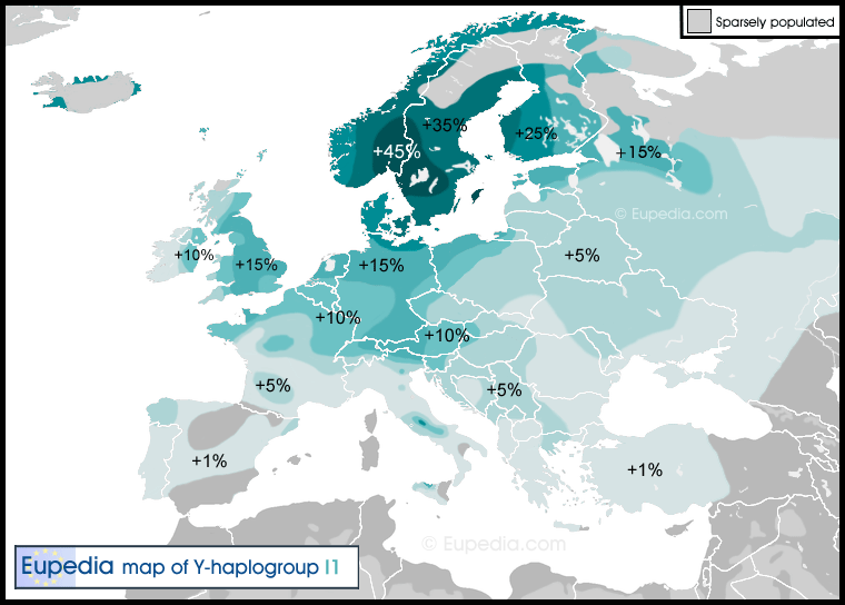
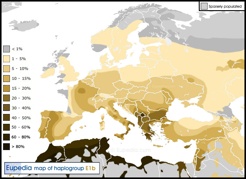
I have cut out the sparsely populated areas on the Y-DNA maps. I think it gives a better idea of the true distribution of haplogroups in the Middle East and North Africa, where deserts have played an important role in shaping the local demography.

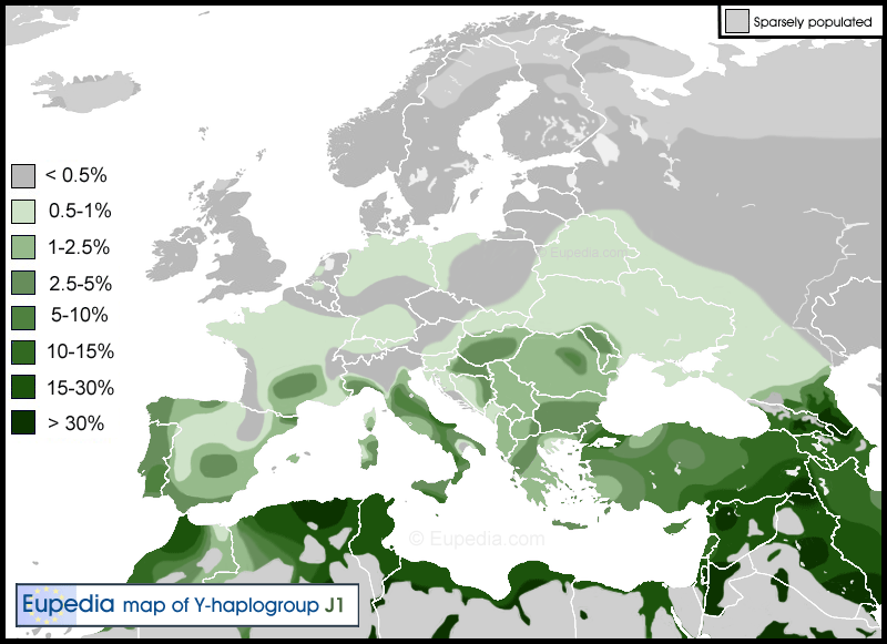
Here are some examples (refresh your browser if you can't see the light grey areas):

Haplogroup-J1.gif


Haplogroup-E1b1b.jpg
 
cool feature;
In Europe i think only Russia and Scandinavia have truly uninhabited districts;
 
cool feature;
In Europe i think only Russia and Scandinavia have truly uninhabited districts;

You are right. I was planning to add them. I am now working on it.
 
This is wrong way of maping haplogroups I think. You are not mapping the density of population, to ignore sparsley populated areas. You are mapping percentage of male or female population belonging to certain haplogroup. Let say, take haplo E in Sahara desert. According to your new map it means if 10 people live in the desert, one of them is E, since yor colour says less than 1%, when in fact over 5 of them are E. So the new maps are wrong, and the thread should be closed. I personally appriciate your efforts in all other maps, Even though I doubt their accuracy. Not for your abilities to draw the maps, but genetic data for many regions are minimal.
 
This is wrong way of maping haplogroups I think. You are not mapping the density of population, to ignore sparsley populated areas. You are mapping percentage of male or female population belonging to certain haplogroup. Let say, take haplo E in Sahara desert. According to your new map it means if 10 people live in the desert, one of them is E, since yor colour says less than 1%, when in fact over 5 of them are E. So the new maps are wrong, and the thread should be closed. I personally appriciate your efforts in all other maps, Even though I doubt their accuracy. Not for your abilities to draw the maps, but genetic data for many regions are minimal.

Dark grey means <1% of one haplogroup. Light grey means not represented because sparsely populated. See here with I1:

Haplogroup_I1.gif
 
You are right. I was planning to add them. I am now working on it.
Drawing uninhabited deserts is good idea, but in case of norhern Russia it is not so good. There are populations tested for DNA, so i thing they should be shown.
 

This thread has been viewed 6832 times.

Back
Top