map of diffusion of SRY2627 proposed by Victar mas in 2011. I quite agree with that, as it explains the presence of SRY2627 in the british isles, along the french atlantic coasts, northern France, and more rarely in Eastern France, Benelux and Germany (backward migration to the East)
Install the app
How to install the app on iOS
Follow along with the video below to see how to install our site as a web app on your home screen.

Note: This feature currently requires accessing the site using the built-in Safari browser.
You are using an out of date browser. It may not display this or other websites correctly.
You should upgrade or use an alternative browser.
You should upgrade or use an alternative browser.
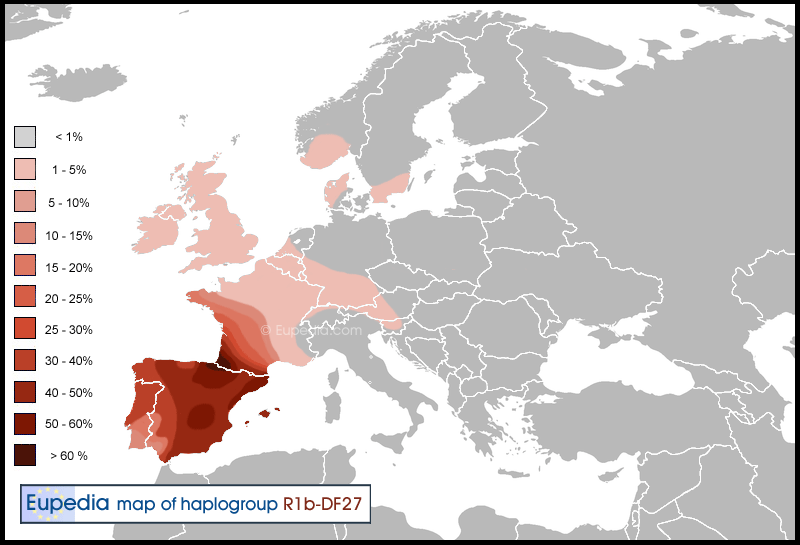
New map of R1b-DF27 (SRY2627 + M153)
martiko
martiko
- Messages
- 213
- Reaction score
- 10
- Points
- 0
- Ethnic group
- european : basqueR1b/IberianI2b
- Y-DNA haplogroup
- R1b-DF100
- mtDNA haplogroup
- T1a1
map of diffusion of SRY2627 proposed by Victar mas in 2011. I quite agree with that, as it explains the presence of SRY2627 in the british isles, along the french atlantic coasts, northern France, and more rarely in Eastern France, Benelux and Germany (backward migration to the East)
damage that the mapping is not enlivened with the chronology to show progress from the east towards ends of Europe, what for them was the search of the ends of the earth.
DF Andrews
Junior Member
Greetings All!
I am new to the forum. I am still working my way through the SNPs of P312. I reside in Pensacola, Florida USA.
DF Andrews
I am new to the forum. I am still working my way through the SNPs of P312. I reside in Pensacola, Florida USA.
DF Andrews
Robin_Perry
Junior Member
- Messages
- 1
- Reaction score
- 0
- Points
- 0
- Ethnic group
- DF27 Gascon Iberian Celtic
- Y-DNA haplogroup
- R-Z198
- mtDNA haplogroup
- H3
Hello, I've recently been y-dna tested by Geno 2.0 and placed in the z198 (more or less equivalent to L176.2?) group under DF27. I am here trying to learn a bit more about my roots. I'm a Yank by birth and do not have a whole lot of family history to proceed with in my search. Thank you for the maps and information! Robin
Hauteville
Elite member
- Messages
- 820
- Reaction score
- 162
- Points
- 0
- Ethnic group
- Italian
- Y-DNA haplogroup
- I-S185
- mtDNA haplogroup
- U5b2b
Sarno et al. founded DF27 in Enna (2,5%) and Catania (1,92%).
IberoAtlantid
Junior Member
- Messages
- 5
- Reaction score
- 0
- Points
- 0
- Ethnic group
- Celtiberian+Goth
This map says that great part of Andalusia was restocked with Catalans and Basques, for example, I have 2/16 Basques surnames and 2/16 Catalan Surnames ") .
.
.Twilight
Regular Member
- Messages
- 956
- Reaction score
- 91
- Points
- 28
- Location
- Clinton, Washington
- Ethnic group
- 15/32 British, 5/32 German, 9/64 Irish, 1/8 Scots Gaelic, 5/64 French, 1/32 Welsh
- Y-DNA haplogroup
- R1b-U152-Z56-BY3957
- mtDNA haplogroup
- J1c7a
Very doubtful since it is a subclade of P312/S116. I think it represents the first migration of R1b Indo-Europeans from central Europe to south-west Europe, circa 2300 BCE. As I have explained in How did the Basques become R1b ?, this R1b migration was probably carried by a group of Indo-European men, adventurers mounted on horses and equipped with bronze weapons in search of easy conquest and loot in Neolithic western Europe. It took over 500 years for the Bronze Age to spread around all Iberia (from 1800 to 1300 BCE) because no proper Bronze Age culture emerged before the wider Atlantic Bronze Age (1300-700 BCE). Before that there were only isolated settlements where bronze weapons have been found, but no evidence of bronze producing societies making use of bronze technologies for everyday life. I believe that this is a sign that for this half millennium Iberia was ruled by warlords of Indo-European (R1b) origin, who had lost their Indo-European language and heritage after a few generations. It is likely that Indo-European languages did not really take hold in Iberia (in the north-west at least) during the Hallstatt expansion around 600 BCE. That doesn't mean that R1b wasn't present in Iberia before that of course. R1b had just become acculturated because of the lack of organised migration of whole tribes with women and children.
It appears that there was a Celtic trade route that went from Tartessos, Spain up into Cornwall; Tin Trade and Cornwall traded with the Irish Celtic Sea. Here is the source of the map below, sorry that I couldn't link the map to you for I couldn't find it anywhere else but here.
Source: Barnes, Ian, Dr. "Celtic Trade." The Historical Atlas of the Celtic World. Edison: Chartwell, 2009. 28-29. Print.
It also looks like Iberian Dna borders on the Irish mainland; this border seems to stretch from Ashford to Cork Harbor. Here is the map http://i1.wp.com/www.cjroots.com/wp...estryDNA-Colleen-Greene-Iberian-Peninsula.png
Ron Lindsay
Junior Member
- Messages
- 4
- Reaction score
- 0
- Points
- 0
- Ethnic group
- Caucasian
- Y-DNA haplogroup
- R1b - DF27
I am a new DF27 subscriber to this forum and this is my first post. I am delighted to see the DF27 map and would like to know more about the specific academic studies that provided the support for the placement of DF27 in the geography of Gascon and Iberia. My sincere thanks to all the contributors for all the material that is posted at this site.
Promenade
Banned
- Messages
- 288
- Reaction score
- 95
- Points
- 0
- Y-DNA haplogroup
- R1b-U106 R-L1
- mtDNA haplogroup
- H1e
I am a new DF27 subscriber to this forum and this is my first post. I am delighted to see the DF27 map and would like to know more about the specific academic studies that provided the support for the placement of DF27 in the geography of Gascon and Iberia. My sincere thanks to all the contributors for all the material that is posted at this site.
Is Lindsay your surname? I would be curious as well if I my paternal ancestry was from the British isles and I had a predominately Iberian Y-DNA subclade. I don't know Maciamo's source for the map but I checked your Surnames group project on FTDNA and a large number of Lindsay's share your subclade, DF27.
There is also a large Lindsay surname DNA project you may want to look into, http://isogg.org/wiki/Lindsay_Surname_DNA_Project
Ron Lindsay
Junior Member
- Messages
- 4
- Reaction score
- 0
- Points
- 0
- Ethnic group
- Caucasian
- Y-DNA haplogroup
- R1b - DF27
Hi Promenade, thanks for your reply. I am the administrator of the International Lindsay Surname DNA Project which was initiated in 2002 and currently "housed" at the FTDNA web site, with over 290 current participants worldwide. Our Lindsay DNA Groups 2 and 3 are both DF27. I have been further tested positive for ZZ12.1 . You may also wish to take a look at the Lindsay International web site which I created in 2001. I am trying hard to determine who my Lindsays were before they became Lindsays.
Mikewww
Elite member
- Messages
- 200
- Reaction score
- 36
- Points
- 0
- Y-DNA haplogroup
- L705.2/L159.2/Z220
- mtDNA haplogroup
- H*
I had been postponing the creation of this map until more data was available, especially for France and Central Europe. But as this could take years, I've decided to make the map anyway and update it later once new studies will be published. So please take it with a pinch of salt.
The map is mostly based on the data for SRY2627 (M167) and M153. I expect the overall frequency to be higher once other subclades will be brought to light.
These maps are great. I would like to include them on a couple of the R1b project overview pages so and am happy to cite Eupedia or Maciamo Hay directly as is desired. Is that okay to include this image on project web page, i.e. the R1b-DF27 project, or in the case of R1b overall, the R1b total map for that project?
razyn
Regular Member
- Messages
- 57
- Reaction score
- 7
- Points
- 0
- Y-DNA haplogroup
- RP312 DF27 Z196 Z220
Is that okay to include this image on project web page, i.e. the R1b-DF27 project
I realize that Mike is an admin too, but as the admin who actually sorts the DF27 project on a day to day basis, I'd like to note that Maciamo's 2013 map of some portion of DF27 is badly out of date, and does not represent either the extent or the percentages of the haplogroup as a whole. His original caption clearly states that it is mostly SRY2627 and M153. Even if a bit more is shown from a couple of academic projects (such as Myres et al, and Busby et al), they were published before comprehensive NextGen sequencing data were available to their authors. Much more representative trees are now available, though maps based on them generally are not.
For example, Alex Williamson's "Big Tree" currently has 523 samples below DF27. 48 of them are SRY2627, and 8 are M153. The rest are neither, and most of them are not reflected in the stats underlying Maciamo's map. Even if we charitably include all of Z198 (near kin of SRY2627), that's only 113. So this 2013 map is missing somewhere between 77% and 89% of DF27 as known to Alex. He just sees what is made available to him, mostly by individual owners of NextGen sequenced kits (plus the 1000 Genomes Project). It is not a scientific sample; but the genetic diversity and geographical spread of DF27 that the Big Tree reveals is no less real, for having largely been volunteered by interested customers of FTDNA and FGC.
I should really like to see a realistic DF27 map, but I have not seen one. Personally, I would rather wait for improvements than to keep linking this early effort all over cyberspace. Improvements in the data are still coming in almost daily, so it's a moving target. It wasn't frozen in 2013, and if try we bring it up to date, it may yet be proven inadequate (when, for instance, France or Romania has a big NextGen project for YDNA).
Also, heat maps tend to make people assume that our contemporary hot spots are pointers to the haplogroup's place of origin. For most haplogroups, that is not the case. People don't normally stay in one area for 5,000 years; they move, now and then. This has happened many times among the subclades of DF27, several of which parted company from one another a few thousand years ago.
Last edited:
Mikewww
Elite member
- Messages
- 200
- Reaction score
- 36
- Points
- 0
- Y-DNA haplogroup
- L705.2/L159.2/Z220
- mtDNA haplogroup
- H*
The DF27 Pack is probably a bad example, but most of these frequency maps in R1b are fair representations of what scientific studies have surveyed. It's the best the we've got anyway.These maps are great. I would like to include them on a couple of the R1b project overview pages so and am happy to cite Eupedia or Maciamo Hay directly as is desired. Is that okay to include this image on project web page, i.e. the R1b-DF27 project, or in the case of R1b overall, the R1b total map for that project?
Is there any problem with adding one of these graphic map images to a project page, given a a proper citation to Eupedia is included?
I have updated the R1b-DF27 map based especially on the data from Valverde et al. (2016), and to a lesser extent Lucotte et al (2015).
The previous map involved a lot of guesswork based on R1b-S116 subclades that excluded L21, U106 and U152, and limited data on M153 and SRY2627. Now the situation is clearer, especially in Spain.
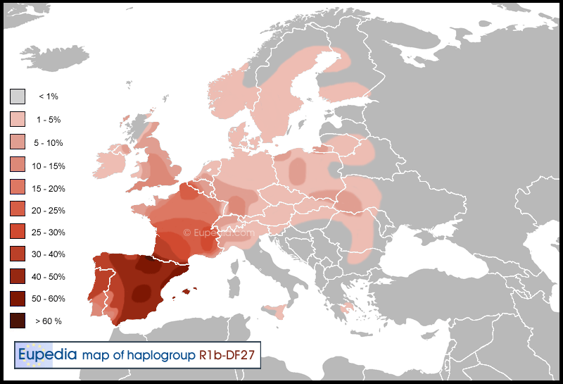
The previous map involved a lot of guesswork based on R1b-S116 subclades that excluded L21, U106 and U152, and limited data on M153 and SRY2627. Now the situation is clearer, especially in Spain.
Last edited:
berun
Regular Member
- Messages
- 1,084
- Reaction score
- 183
- Points
- 0
Much caution needed with the Valverde paper; they tested people from Alicante, Madrid and Barcelona, and such cities have levels of 50-60% of people with a recent migratory past, so they are not representative of the regional genetics of lets say the XIX century. In fact Madrid was a little town till it was converted in the Spanish capital in the XVI century, attracting all time people and people from everywhere till reaching the actual 3 milions. For the Basques at least they got the results from those having Basque surnames, and this is a good alternative to obtain real regional DNA keeping out recent additions and admixtures (half of the Basque population and/or their fathers were born in other Spanish regions).
Hauteville
Elite member
- Messages
- 820
- Reaction score
- 162
- Points
- 0
- Ethnic group
- Italian
- Y-DNA haplogroup
- I-S185
- mtDNA haplogroup
- U5b2b
There are some SRY2627 also in Italy, you can see it into Boattini, Sarno and Tofanelli studies. I've a contact from Piemonte who has got this haplogroup.
razyn
Regular Member
- Messages
- 57
- Reaction score
- 7
- Points
- 0
- Y-DNA haplogroup
- RP312 DF27 Z196 Z220
I have updated the R1b-DF27 map
Thanks very much for the update, I'll link it in places that ought to know.
You should, in turn, be aware that within the past month there has been an aDNA breakthrough of sorts. The first, and so far the only undisputed, ancient DNA example of DF27 has been detected in sample I0806, a carbon-14 dated Bell Beaker burial (in a predominantly Corded Ware cemetery) in Quedlinburg, Germany. This is northeast of any pink area on your latest map; but it's just one middle-aged guy, born about 4300 years ago. That's several thousand years too old, and a few months too recently discovered, to have affected 21st century academic publications (or heat maps based on them) in any way. Probably the best place to read up on it is here: http://www.anthrogenica.com/showthr...-did-it-expand&p=186674&viewfull=1#post186674
Some of the subsequent posting on that thread is off-topic; but it is where I (and others) try to paste in useful links to discoveries, publications, or posts elsewhere that are pertinent to this map and discussion.
A. Papadimitriou
Regular Member
- Messages
- 617
- Reaction score
- 188
- Points
- 43
I have updated the R1b-DF27 map based especially on the data from Valverde et al. (2016), and to a lesser extent Lucotte et al (2015).
The previous map involved a lot of guesswork based on R1b-S116 subclades that excluded L21, U106 and U152, and limited data on M153 and SRY2627. Now the situation is clearer, especially in Spain.
What study found it in Greece?
The guy from the Greek FTDNA project who has it must be Arvanite or Vlach but not from there supposedly.
Maybe Arvanite of Catalan origin. It would make sense for those who know Greek history, although it would seem weird.
Ron Lindsay
Junior Member
- Messages
- 4
- Reaction score
- 0
- Points
- 0
- Ethnic group
- Caucasian
- Y-DNA haplogroup
- R1b - DF27
Hi Belmonde,
When you state "Family Tree" ... I assume you are referring to Family Tree DNA laboratory in Houston ... will you tell me where you find this type information at FTDNA?
When you state "Family Tree" ... I assume you are referring to Family Tree DNA laboratory in Houston ... will you tell me where you find this type information at FTDNA?
This thread has been viewed 57976 times.