Byzantium

Europe at the Death of Charlemagne (814 AD)
map038.jpg


This map shows the area of the Kingdom of the Asturias, The Omayyad Emirate of Kurtuba, Slavania, the Kingdom of the Avars, Sclavinia, the Kingdom of the Khazars, and more.

Source: Bartholomew, J.G. LLD. A Literary & Historical Atlas of Europe. London: J.M. Dent & Sons, Ltd. and New York: E.P. Dutton & Co., 1910. 14-15.
 
The Carolingian and Byzantine Empires (ca. 814 AD)
map068.jpg


The boundaries of the Carolingian Empire, the Byzantine Empire, the Caliphate, and the Slavic peoples tributary to Charlemagne are displayed on this map.

Source: Sheperd, William R. Historical Atlas. New York: Henry Holt and Company, 1911. 54-5.
 
The thing is, that the term 'Byzantine empire' has been thought of after the fall of the eastern Roman empire. The eastern Romans saw themselves as Romans, most of them spoke Greek and not Latin, but Romans they saw themselves as. Just like the Roman Britons never really adopted Latin (it was scarce), rather, continued to speak Celtic languages.


Flavians kept their latin language, at least in rulling and laws.

we say Codex Thodosianus,
Codex Justinianus etc,

after Basileios 1rst we se words like Χρυσοβουλον (gold sealed)
 
Tenth Century Europe (ca. 980 AD)
map011.jpg


This map shows Europe as it looked during the later tenth century.

Source: Dow, Earle W. Atlas of European History. New York: Henry Holt and Company, 1907. Plate 8.
 
Europe and the Byzantine Empire (ca. 1000 AD)
map071.jpg

View the boundaries of Europe and the Byzantine Empire around 1000 AD. The map also shows the route of the Varangians.

Source: Sheperd, William R. Historical Atlas. New York: Henry Holt and Company, 1911. 58-9.
 
Europe and the Mediterranean Lands (ca. 1097 AD)

map080.jpg

This map not only shows European lands and the Western-held lands to the East, but it also shows the routes of leaders during the first Crusade, including Godfrey of Bouillon, Adhemar of Puy and William of Toulouse, Bohemond and Tancred, and the route of combined forces.

Source: Sheperd, William R. Historical Atlas. New York: Henry Holt and Company, 1911. 66-7.
 
The Crusader States (ca. 1099 AD)
map012.jpg

Following the successes of the First Crusade, the Franks established a series of crusader states. This map shows each of them at their greatest extent.

Source: Dow, Earle W. Atlas of European History. New York: Henry Holt and Company, 1907. Plate 92.
 
Asia Minor and the States of the Crusaders in Syria (ca. 1140 AD)

map081.jpg

This map focuses on Western-held lands in Asia Minor and the crusader states.

Source: Sheperd, William R. Historical Atlas. New York: Henry Holt and Company, 1911. 68.
 
Europe at the Time of the Crusades (1189 AD)
map042.jpg


This map shows Europe at the time of the First Crusade.

Source: Bartholomew, J.G. LLD. A Literary & Historical Atlas of Europe. London: J.M. Dent & Sons, Ltd. and New York: E.P. Dutton & Co., 1910. 20-1.
 
Europe in 1190 (1190 AD)
map013.jpg


View a map of Europe as it appeared at the time of the Third Crusade.

Source: Dow, Earle W. Atlas of European History. New York: Henry Holt and Company, 1907. Plate 9.
 
Europe and the Mediterranean Lands (ca. 1190 AD)

map085.jpg

On this map see the crusade of Louis VII and Conrad III between 1147 and 1149 AD, the crusade of Richard I (Lionhearted) and Philip II (Augustus), and Frederick I (Barbarossa) between 1189 and 1191 AD, and more.

Source: Sheperd, William R. Historical Atlas. New York: Henry Holt and Company, 1911. 70-1.
 
The Eastern Mediterranean (ca. 1204 AD)
map014.jpg

This map depicts Southeastern Europe and Asia Minor after the Fourth Crusade.

Source: Dow, Earle W. Atlas of European History. New York: Henry Holt and Company, 1907. Plate 9.
 
The Mediterranean Lands after 1204 (ca. 1204 AD)
map087.jpg

See the route of the Fourth Crusade from 1202 to 1204, the crusade of Frederick II from 1228-1229, and the Crusades of Louis IX from 1248 to 1254 and in 1270. The map also shows Venetian possessions and Genoese cities after 1261.

Source: Sheperd, William R. Historical Atlas. New York: Henry Holt and Company, 1911. 73.
 
The Byzantine Empire (1265 AD)

map106.jpg


This map shows the Byzantine Empire in 1265 AD, as well as the Empire of Trebizond, the despotat of Epirus, the kingdoms of Bulgaria and Servia, the Wallachian states, states under Latin rule, the palatinate of Cephalonia, Venetian possessions, Mongol dominions and Seljuk Turks, the dominion of the Mamelukes, and more.

Source: Sheperd, William R. Historical Atlas. New York: Henry Holt and Company, 1911. 89.
 
The Mongol Dominions (1300-1405 AD)

map108.jpg


View the approximate limits of the Mongol dominions about 1300 AD, the approximate extent of the dominions of Timur in 1405, the possessions of the Ottoman Turks before and after the battle of Angora in 1402 AD, and more.

Source: Sheperd, William R. Historical Atlas. New York: Henry Holt and Company, 1911. 92.
 
The Byzantine Empire and the Ottoman Turks in 1355 (1355 AD)

map107.jpg


See the Byzantine Empire, Greek Empire of Trebizond, the kingdoms of Armenia, Servia, and Bulgaria, the Ottoman Turks, other Turks, states under Latin rule, Venetian possessions, Genoese possessions, the dominion of the Mamelukes, and more.

Source: Sheperd, William R. Historical Atlas. New York: Henry Holt and Company, 1911. 89.
 
Europe (1360 AD)

map092.jpg


See Europe in 1360 AD. Duchies, kingdoms, and principalities are indicated on the map.

Source: Sheperd, William R. Historical Atlas. New York: Henry Holt and Company, 1911. 77.
 
The Ottoman Empire (1451-1481 AD)
map109.jpg


In addition to the dominions of the Ottoman Turks and those were acquired between 1451 and 1481, view the remnants of the Byzantine Empire and its dependencies in the Peloponnesus, the Greek empire of Trebizond, Servia, Bosnia, Herzegovina, Montenegro, Albania under George Castriota, states under Latin rule, Venetian and Genoese possessions, the dominion of the of the Circassian Mamelukes, and more.

Source: Sheperd, William R. Historical Atlas. New York: Henry Holt and Company, 1911. 93.
 
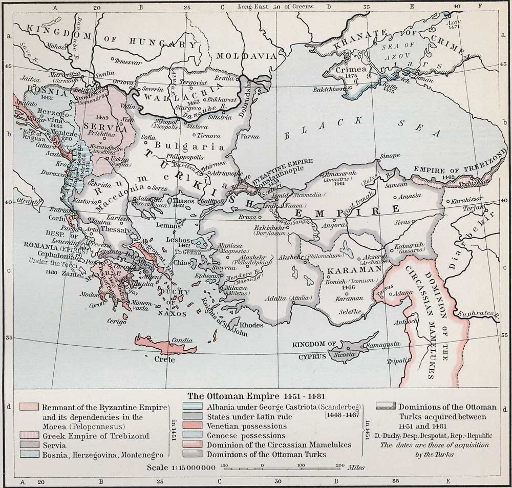
I understand the Latin-Greek duality of the Byzantine Empire up to the schism, but after that, speaking Italian-Latin was not such a good idea anymore. Also anything remotely related with Catholicism and Rome, was seen as heresy. So they stopped being friends and started competing for control over the mediterannean world, which culminated with the destruction of Costandinople by the Crusaders. When the turks came, they just "collected the bones" of a dead empire. The Turks were never that strong to match Byzant at its peak; as proof, for 25 years after the fall of Constandinople the whole Ottoman Empire was held back and defeated by a few thousand Albanians under Skanderbeg. So these guys still calling themselves Roman after the schism, would be more for political reasons on their part.


WRONG

the biggest hate was due to 4rth Crusade,
Turks were already in minor Asia,
Manjikert Mtzikert or how ever written battle was 1 century before,

Turks with their Allies Kurds won the battle against Rums, Varrangians and their allies,
that opened the road to Konya and West minor Asia to Turks,

Schism has nothing to do, mostly in religious circles,
if search General Maniakis story, his Orthodox army left from Orthodox south Italy, just to replace their General honor, the revolt of Arbanites,

So schism was nothing,
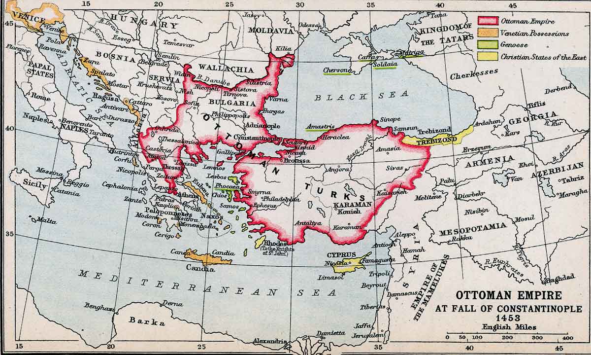
it was the lost of Battle of Majikert, and the crusaders, whom Byzantines believe that will help against Islam, sucked Con/polis.

Crusades and especially 1204 is a catalytic date for East Roman empire and West Europe rise in sciences and politics,
Although it started before, from Peter the Hermit
 
And the end of this tour in the history of the Eastern Roman Empire through maps, THE FALL OF CONSTANTINOPOLI

Ottoman Empire at the Fall of Constantinople (1453 AD)
map047.jpg


This map shows the Ottoman Empire, Venetian possessions, Genoese possessions, and Christian states in the East.

Source: Bartholomew, J.G. LLD. A Literary & Historical Atlas of Europe. London: J.M. Dent & Sons, Ltd. and New York: E.P. Dutton & Co., 1910. 28.
 

This thread has been viewed 75486 times.

Back
Top