"Roads to Rome"

Jovialis

Advisor
Messages
9,309
Reaction score
5,857
Points
113
Ethnic group
Italian
Y-DNA haplogroup
R-PF7566 (R-Y227216)
mtDNA haplogroup
H6a1b7
7mIuzbW.png


The well-known saying "all roads lead to Rome" seems to be true, at least, that's what the Moovel Lab team in Stuttgart, which is dedicated to urban mobility research, points out. Titled "Roads to Rome," the project has mapped out over-land routes across Europe that converge to the city.

From a grid of 26,503,452 square kilometers covering all of Europe, the researchers defined 486,713 starting points that were superimposed on the continent's street map. Then an algorithm was developed for the project that calculated the shortest route between each of the points and the Italian capital.

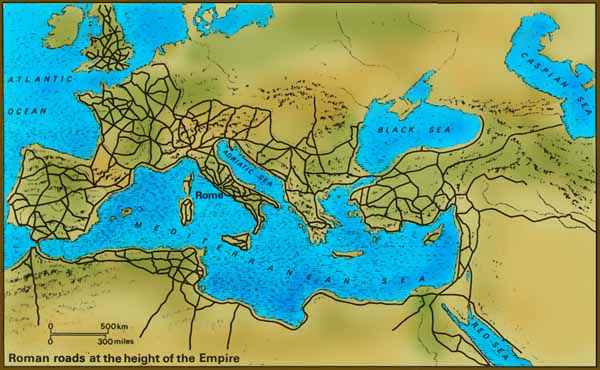
The resulting cartography reveals a route map that, in fact, leads to Rome. The thicker lines represent the most used routes and are the roads where the smaller routes converge.

In its glory days, the Roman Empire was responsible for creating an extensive network of thoroughfares throughout the European continent, from Britain to Turkey, interconnecting its 113 provinces by means of 373 routes that were more than 80 thousand kilometers long. Today, some of Europe's major highways exist on ancient Roman roads.


https://www.archdaily.com/893076/apparently-all-roads-do-lead-to-rome

http://roadstorome.moovellab.com/maps/roads-to-rome/#4.64/44.504/16.341
 
That's incredible! It looks like the veins on a leaf or a body's vascular system!

Sent from my Redmi 5 Plus using Tapatalk
 
Really interesting.
Has anyone tried to overlap this map with others bearing proximity or reciprocal genetic flows among european peoples?
 
I recall somewhere that when planning economic highways for goods transportations they used and tried a system based on Ants, finding the most logical routes to connect all distribution centres and destinations, and it proved the best option, not sure if it was in Uk or USA but that map reminded me of it.
 
Here is the road system at the height of the Roman Empire. The most extensive system was still in the Center. The north was the least developed.
romanroadmapa.jpg


This neat map shows you the location of some of the famous major Roman roads within Italy itself. So, if you happen to be reading something like "Quo Vadis" and it says Peter took the Via Appia to leave the city you know what it means. :)
la-circolazione-dai-romani-al-primo-cds_2.jpg


On my first trip to Rome one of the first things I did was to go to the parts of the Via Appia which still remain.

2007-01-111.jpg


What has happened is that sometimes the modern road is on top of the ancient one and sometimes it's right next to it.
via-emilia-scauri.jpg
 
Interesting thought i don't see Via Egnatia link with via Appia from Byzantium "Constantinople" to Rome.
https://en.wikipedia.org/wiki/Via_Egnatia

800px-Via_Egnatia-en.jpg


This are some of the original remains of the road in Radozhda,Macedonia
800px-Via_Egnatia_Radozda.JPG


Near Kavala,Neapolis
800px-Kavala_egnatia_1.JPG

It's on the first map I posted, but it wasn't labeled nicely and in such detail as in this map.
 
"Then an algorithm was developed for the project that calculated the shortest route between each of the points and the Italian capital. "

It is nothing about history. Not show Roman roads.

It is based on current modern roads and cities. Show that how you can go Rome. So with an true algorithm, you can do it for every city.

Just If you are Italian and got lost in Europe, you can use this map.
 

This thread has been viewed 6208 times.

Back
Top