LeBrok
Elite member
- Messages
- 10,261
- Reaction score
- 1,617
- Points
- 0
- Location
- Calgary
- Ethnic group
- Citizen of the world
- Y-DNA haplogroup
- R1b Z2109
- mtDNA haplogroup
- H1c
I came upon a very interesting article and maps about the extent of Ice Age glaciers with enormous flood basins. Asia as we know it today didn't exist in the past. It was more of landscape of separate lands with huge seas between them and mountains of ice. Till pretty much the end of Ice Age there were communities separated for a long time from each other. This scenario could explain why we can find obvious and distinct genetic groupings of ancient populations, as WHG in Europe, ANE in Asia or ENF in Near East. They were stuck in one place and do lots of inbreeding for ten or twenty thousand years, and didn't travel much and didn't mingle till modern warmer interglacial times.
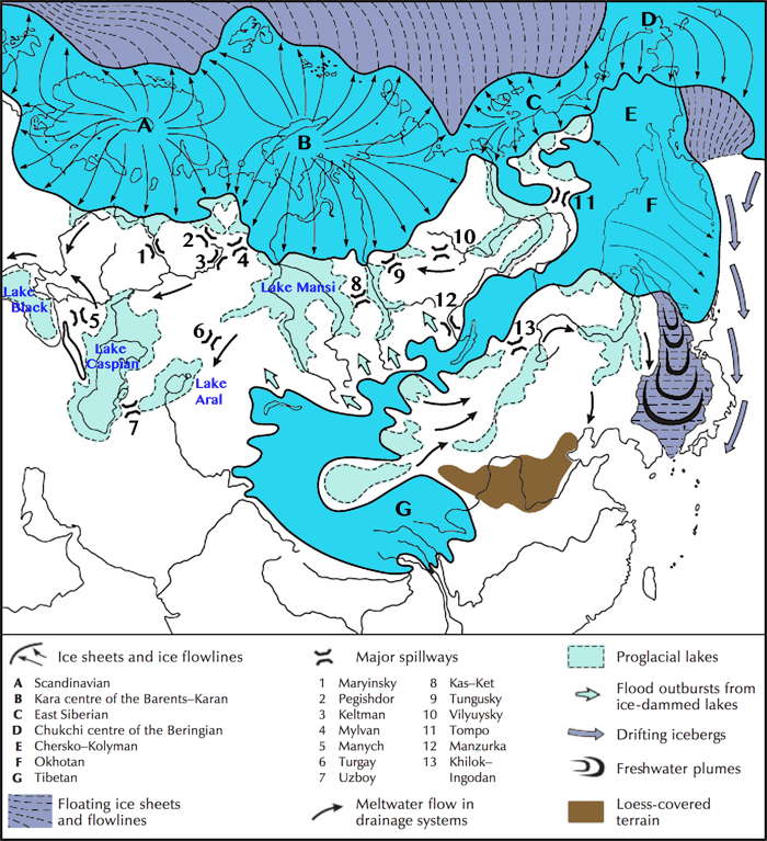
Altaic part is completely separated, and Siberia cut into small almost separate pieces. European Eastern part cut into sections by gigantic rivers emptying to giant lakes. Lakes and mountains there completely cutting off East Europe from Near East. I'm not sure if there was a land bridge between Balkans and Anatolia. The giant lakes were constantly draining the melt water to Mediterranean Sea.
However, with onset of winters, everything in upper Asia had to be frozen solid. At this time traveling through lakes and rivers would be possible. Especially when hunters are following some migratory herds of animals like reindeer or possibly mammoths. It is hard to know winter practices of these hunters, but judging by their distinct genomes they might not have traveled too far.
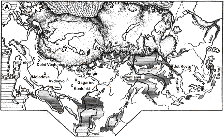
This is 20,000 years ago during glacial maximum. Some friendly sole marked paleolithic places of interest.
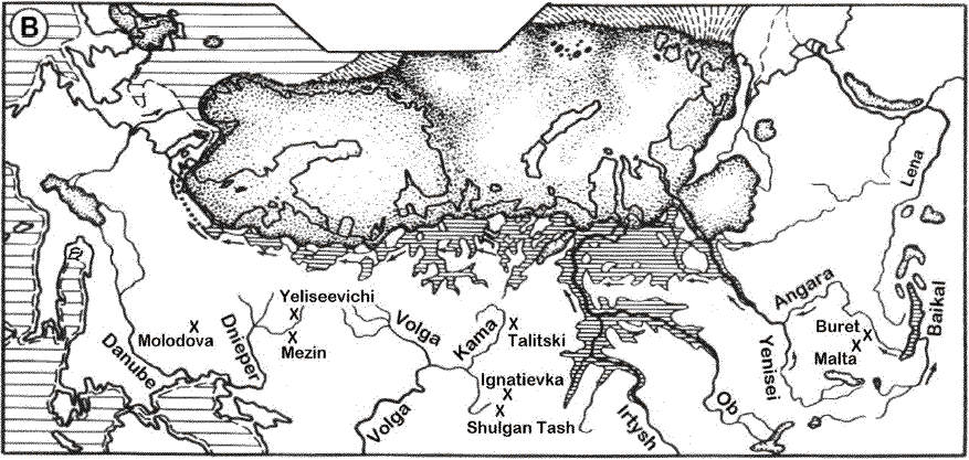
State of affairs 13.000 years ago.
And 10,000
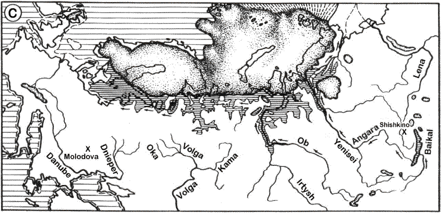
http://donsmaps.com/icemaps.html
There are also maps showing an interesting protrusion of ice sheet towards Black and Caspian Sea. This could seriously curtail mixing of WHG with ANE H-Gs.

http://en.wikipedia.org/wiki/Ice_age#mediaviewer/File:Iceage_north-intergl_glac_hg.png
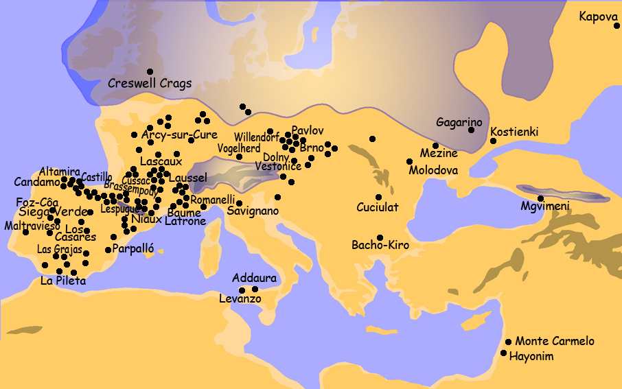
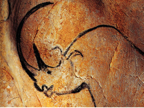
http://www.zonu.com/fullsize-en/2009-12-09-11372/Sites-with-Paleolithic-Art-in-Europe.html
Theoretically this land bridge between Balkans and Anatolia could have helped I2 and C6 hunter-gatherers to enter Near East from Europe and mix with farmers before they expanded into Europe? Though it could have been impassable after glacial maximum when melt water had to flow from Black Sea to Mediterranean almost all the time.
Any idea why Spain, France, Germany and Czechy are so rich in cave settlements, and Balkans or Italy (supposedly with better climate to survive during Ice Age) are almost completely deserted?
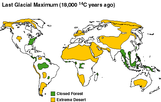
This map shows extend of wooden are during Ice Age. Perhaps these hunters didn't like forests?
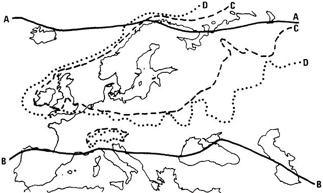
Ice Age conditions in Europe
A: The position of the polar timberline in present-day Europe
B: The position of the timberline at the most severe stage of the Würm Ice Age.
C: The limits of glacial debris deposited during the Würm Ice Age.
D: The limits of glacial debris deposited during the Riss and Mindel Ice Age.
Photo: Secrets of the Ice Age by Evan Hadingham, 1980
Altaic part is completely separated, and Siberia cut into small almost separate pieces. European Eastern part cut into sections by gigantic rivers emptying to giant lakes. Lakes and mountains there completely cutting off East Europe from Near East. I'm not sure if there was a land bridge between Balkans and Anatolia. The giant lakes were constantly draining the melt water to Mediterranean Sea.
However, with onset of winters, everything in upper Asia had to be frozen solid. At this time traveling through lakes and rivers would be possible. Especially when hunters are following some migratory herds of animals like reindeer or possibly mammoths. It is hard to know winter practices of these hunters, but judging by their distinct genomes they might not have traveled too far.
This is 20,000 years ago during glacial maximum. Some friendly sole marked paleolithic places of interest.
State of affairs 13.000 years ago.
And 10,000
http://donsmaps.com/icemaps.html
There are also maps showing an interesting protrusion of ice sheet towards Black and Caspian Sea. This could seriously curtail mixing of WHG with ANE H-Gs.
http://en.wikipedia.org/wiki/Ice_age#mediaviewer/File:Iceage_north-intergl_glac_hg.png
http://www.zonu.com/fullsize-en/2009-12-09-11372/Sites-with-Paleolithic-Art-in-Europe.html
Theoretically this land bridge between Balkans and Anatolia could have helped I2 and C6 hunter-gatherers to enter Near East from Europe and mix with farmers before they expanded into Europe? Though it could have been impassable after glacial maximum when melt water had to flow from Black Sea to Mediterranean almost all the time.
Any idea why Spain, France, Germany and Czechy are so rich in cave settlements, and Balkans or Italy (supposedly with better climate to survive during Ice Age) are almost completely deserted?
This map shows extend of wooden are during Ice Age. Perhaps these hunters didn't like forests?
Ice Age conditions in Europe
A: The position of the polar timberline in present-day Europe
B: The position of the timberline at the most severe stage of the Würm Ice Age.
C: The limits of glacial debris deposited during the Würm Ice Age.
D: The limits of glacial debris deposited during the Riss and Mindel Ice Age.
Photo: Secrets of the Ice Age by Evan Hadingham, 1980

")