• Don't want to see ads? Install an adblocker like uBlock Origin or use a Europe-based privacy-friendly browser like Vivaldi or Mullvad.

Subdivisions of Polish people

Thanks for your feedback. My map is based on several historical and linguistic maps of Poland.

This map for example shows the Masurian dialect as being spoken today in what used to be East Prussia. The Kashubian area matches the one on my map.

image
e6ce8acbf5d341ef86a255701a4c6911.jpg


I am aware of the Goralic and Rusyn dialects in the Carpathians, but their numbers are so small (a few thousands) that I could not include them separately. Keep in mind that the purpose of these maps on Living DNA is to show the percentage of similarity (or presumed inheritance) of an individual with the hundreds of regions in the Old World in the database. It is going to be difficult enough to spot genetic differences between relatively ethnically homogeneous populations like the Poles, so if we go into too much detail from the start, the chances of having wrong results will increase. Note that none of the other Slavic countries have their own project. I insisted that Poland did due to its size and knowing the interest of Poles for population genetics.
 
Thanks for your feedback. My map is based on several historical and linguistic maps of Poland.
This map for example shows the Masurian dialect as being spoken today in what used to be East Prussia. The Kashubian area matches the one on my map.
image
e6ce8acbf5d341ef86a255701a4c6911.jpg

I am aware of the Goralic and Rusyn dialects in the Carpathians, but their numbers are so small (a few thousands) that I could not include them separately. Keep in mind that the purpose of these maps on Living DNA is to show the percentage of similarity (or presumed inheritance) of an individual with the hundreds of regions in the Old World in the database. It is going to be difficult enough to spot genetic differences between relatively ethnically homogeneous populations like the Poles, so if we go into too much detail from the start, the chances of having wrong results will increase. Note that none of the other Slavic countries have their own project. I insisted that Poland did due to its size and knowing the interest of Poles for population genetics.

Ok, but ther eis'n MAsurian Polish in the region you noticed. MAsurians are on the south of Warminsko-Mazurskie voyvodship. On the north are new mixed dialects (Kresoviaks + guys from southern and central Poland mostly).

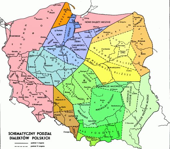
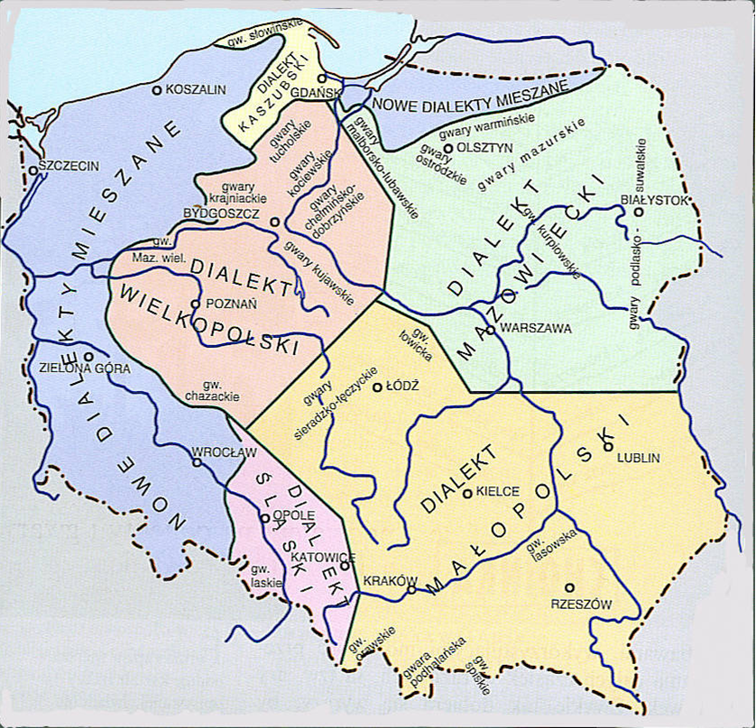
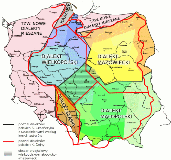
You can use translator https://pl.wikipedia.org/wiki/Dialekty_j%C4%99zyka_polskiego

1024px-Polska-dialekty_wg_Urba%C5%84czyka.PNG


1024px-Polska-dialekty.png
 
As you see Central Poland (Łódź voivodship) vary. On one map is mostly Great Poland, on Second Lesser.

Some other cool maps of dialects

This one will be easily drawed... You see Masurians (Mazury).
podzial.gif


M946.gif


mglowna.gif
 
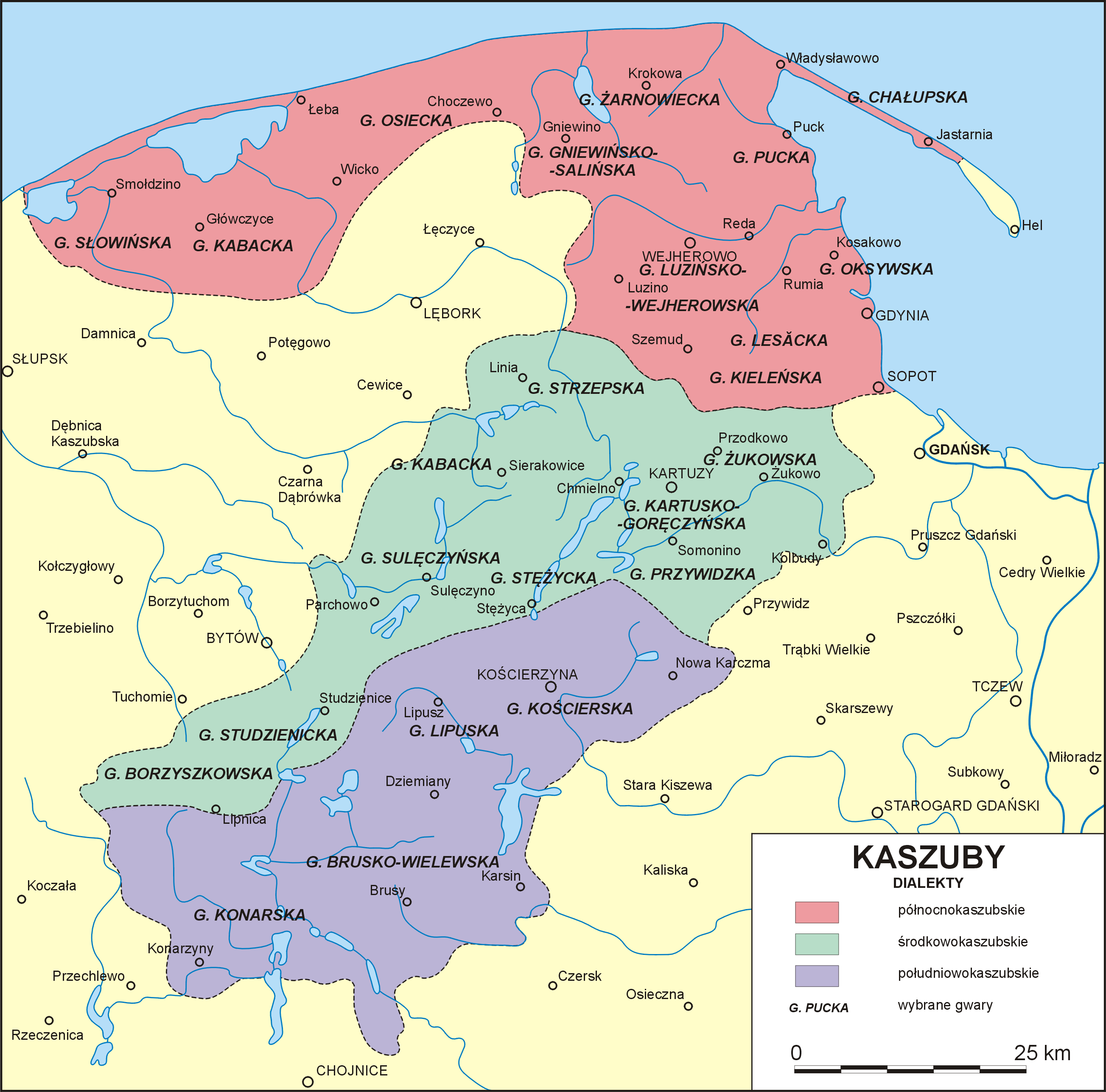
Kashubians
Kaszuby_-_dialekty_wg_F.Lorentza.png
 
latest


Poland1937linguistic.jpg
 
German dialects in Poland (before war)

gwary_germ_pln_Polski.jpg

gwary_niemieckie_Polska_Maurmanna.jpg

gwary_slaskie_niemieckiego_.jpg
 
Thanks again. I looks like the region I defined is really a separate entity, but it would be better to rename it East Prussia instead of Masuria. Is that what you suggest?
 
Thanks again. I looks like the region I defined is really a separate entity, but it would be better to rename it East Prussia instead of Masuria. Is that what you suggest?
I think East-Prussia would be shortest in English. There isn't single Polish name for this region (it's partly Warmia, Powiśle, partly northern Germanic-speaking (before WWII) Masuria, partly southern Konigsberg area).
 
I think East-Prussia would be shortest in English. There isn't single Polish name for this region (it's partly Warmia, Powiśle, partly northern Germanic-speaking (before WWII) Masuria, partly southern Konigsberg area).

Then you see my predicament. It's not always easy to label regions that have shifted a lot through history.
 
As for Kashubia, we should move its western border with Pomerania a bit more to the west. Because this Project is about about grandparents great-grandparents of present-day people. And the linguistic border between German-speakers and Kashubian-speakers was gradually shifting towards the east during the 19th and 20th centuries, due to cultural Germanization and abolition of Slavic sermons in Protestant churches.

These maps illustrate the whole process (check the maps "Kashubians around 1660" and "Kashubians in 19th century"):

http://en.kaszubia.com/kashubians/history/maps

http://gene.truher.net/TBFx/308.html

Western borders of Kashubian majority areas:

https://forum.krstarica.com/showthread.php/432630-Сербски-времеплов/page25

Green - ca. year 1660
Orange - ca. year 1750
Red - ca. year 1850

Leba_Kashubs.png

Slaski.png


Another, more detailed, version of these maps:

http://s17.postimg.org/yqawdplfh/Germ_Kash_1.png

https://s1.postimg.org/5k6skhtmn/Germ_Kash_2.png

Germ_Kash_1.png

Germ_Kash_2.png
 
Linguistic shifts in Pomerania during the recent centuries were mostly cultural (Kashubians becoming German-speakers) rather than demographic (German settlers moving there).

====================================

Some ethno-linguistic maps that might be useful:


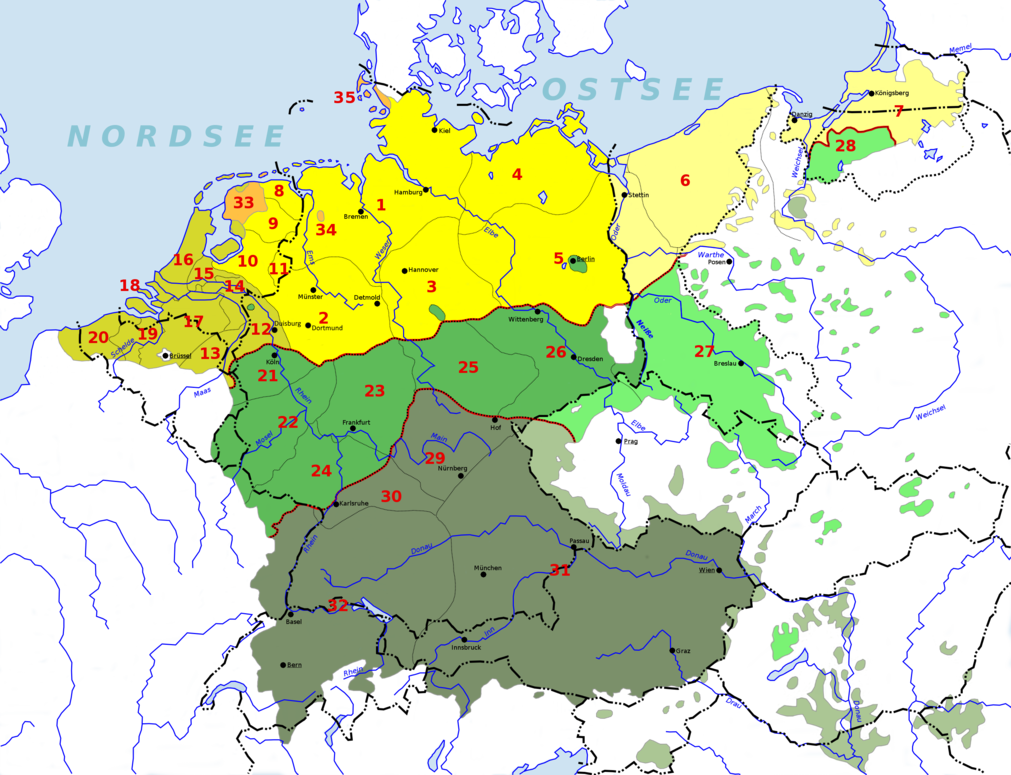
Here is a map of German dialects before the World Wars:

https://upload.wikimedia.org/wikipe...ländischer_Sprachraum_(nach_Werner_König).png

1011px-Deutsch-Niederl%C3%A4ndischer_Sprachraum_%28nach_Werner_K%C3%B6nig%29.png


Percent of ethnic Czechs in Czechia by region, ca. year 1900:

http://terkepek.adatbank.transindex.ro/kepek/netre/10.gif

10.gif


Ethnic groups in eastern part of the Kingdom of Prussia ca. 1816-31:

http://i.imgur.com/oonMdGF.png

oonMdGF.png


East Prussia alone (including Klein Litauen, or Prussian Lithuania):

https://s29.postimg.org/eson19i79/Prussia_ethnic_1800_B.png

Prussia_ethnic_1800_B.png


Ethnic data per county for Masuria (Protestant Polish-speakers):


Sprache / Muttersprache = language
Konfession = religious denomination


1) Kreis Angerburg (Węgorzewo):


Angerburg.png


2) Kreis Goldap (Gołdap):


Goldap.png


3) Kreis Johannisburg (Pisz):


Johannisburg.png


4) Kreis Lötzen (Łuczany / Giżycko):


Loetzen.png


5) Kreis Lyck (Łek / Ełk):


Gumbinnen.png


6) Kreis Mohrungen (Morąg):


Mohrungen.png


7) Kreis Neidenburg (Nibork / Nidzica):


Neiderung.png


8) Kreis Oletzko (Olecko):


Oletzko.png


9) Kreis Ortelsburg (Szczytno):


Ortelsburg.png


10) Kreis Osterode (Ostróda):


Osterode.png


11) Kreis Rastenburg (Rastembork / Kętrzyn):


Rastenburg.png


12) Kreis Rosenberg (Susz):


Rosenberg.png


13) Kreis Sensburg (Ządzbork / Mrągowo):


Sensburg.png


14) Summary for Pisz, Lötzen, Lyck, Neidenburg, Oletzko, Ortelsburg, Osterode & Sensburg:


Summary_8_Kreise.png


^^^
As you can see Polish-speakers were declining over time, but it was a cultural process, so had no impact on DNA. The same was the case with Lithuanian-speakers in Klein Litauen:


Percent of Lithuanian-speakers among the population of East Prussia:


Year - % of Lithuanian-speakers in East Prussia:


1820 - 18,52% (estimate)
1825 - 12,13% (census)
1837 - 11,49% (census)
1848 - 10,26% (census)
1871 - 7,65% (census)
1878 - 6,91% (census)
1890 - 6,19% (census)


^^^ It continued to decline after 1890, but I don't have exact data.
 
Maciamo if you also have influence on how Living DNA divides Germany into regions, then you can tell them that it would be good to have the island of Rügen as a separate region. That's because studies have shown that people of this island have specific distinct genetic differences from people in other parts of Germany.

Actually, populations of Rügen, Ummanz and Hiddensee are all distinct from mainland populations:

https://www.ncbi.nlm.nih.gov/pubmed/14717531

Abstract

24 haemogenetic markers (5 erythrocyte antigens, 7 polymorphisms of serum proteins, 12 polymorphisms of red cell enzymes) had been studied in 171 individuals from the island of Rügen (Germany, Baltic Sea). The cluster analysis separates clearly the Rügen sample just as the islands of Hiddensee and Ummanz from the neighbouring populations. The comparison of the data with neighboured larger populations as for instance Denmark, Hamburg or Sweden clearly results in an exceptional position of the island of Rügen. The possible reasons are discussed. (...)

Maybe "Germany's Baltic Sea Islands" should be a region of its own?:

https://en.wikipedia.org/wiki/List_of_islands_of_Germany#Islands_of_the_Baltic_Sea

Rügen - 926 km2 and 77,000 people
Usedom (German part) - 373 km2 and 31,500 people
Fehmarn - 185 km2 and 12,467 people
Poel - 36 km2 and 2,497 people
Hiddensee - 19 km2 and 1,002 people
Ummanz - 20 km2 and 274 people
==========================
Greifswalder Oie - small island near Usedom
Dänholm - small island near Rügen
Vilm - small island near Rügen
Walfisch island - uninhabited
Langenwerder - uninhabited
Ruden - uninhabited
==========================
Total population - 125,000 people
 
I think East-Prussia would be shortest in English. There isn't single Polish name for this region (it's partly Warmia, Powiśle, partly northern Germanic-speaking (before WWII) Masuria, partly southern Konigsberg area).

https://en.wikipedia.org/wiki/Duchy_of_Prussia

^^^
I'm not sure if it is a good idea to make it one region. As for single Polish name - there is Prusy Książęce (Ducal Prussia), but it does not include Warmia (Ermland). Ducal Prussia was Protestant. Warmia was Catholic. Even German-speakers in Warmia were Catholic, while Polish-speakers in Ducal Prussia were Lutheran. Catholic Germans should be genetically distinct from Protestant Germans, because they rarely intermarried. Here some maps showing political and religious borders in this region:

Western borders of Poland in the 1600s and the 1700s:

http://files.foreignaffairs.com/legacy/images/10403-1.jpg

10403-1.jpg


http://i.imgur.com/1Oj4u3x.png

1Oj4u3x.png


Trzemeszno Lubuskie was the westernmost town of the Polish-Lithuanian Commonwealth:

http://i.imgur.com/WjCxmUV.png

WjCxmUV.png


http://i.imgur.com/3UE5KZk.jpg

3UE5KZk.jpg


https://s32.postimg.org/mozorbyud/PL_GER_west_border.png

PL_GER_west_border.png


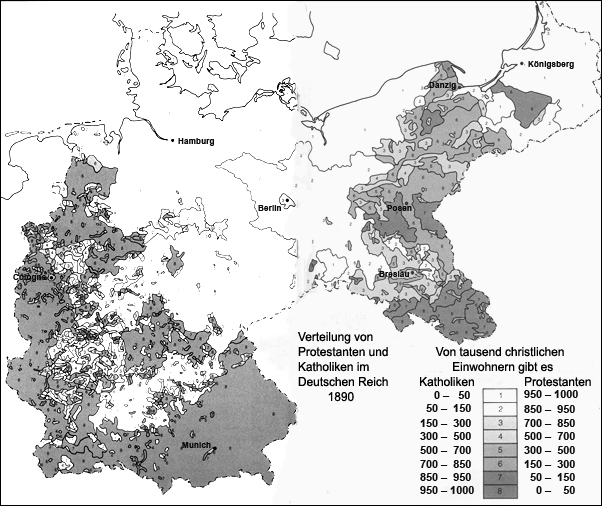
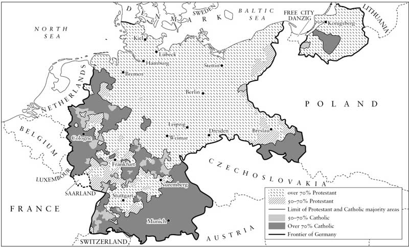
Religions:

https://s10.postimg.org/3n5o64ubt/Cat_Prot1.png

Cat_Prot1.png


https://s18.postimg.org/p3jj791yx/Kat_Prot2.png

Kat_Prot2.png


Before World War 1:

http://germanhistorydocs.ghi-dc.org/images/Geographische Verteilung.jpg

Geographische%20Verteilung.jpg


Between WW1 and WW2:

http://3.bp.blogspot.com/-8LkZNUQHSD4/T4WJSJMvMAI/AAAAAAAAALE/MAqr0gsOAAQ/s1600/Religion.jpg

Religion.jpg
 
I think East-Prussia would be shortest in English. There isn't single Polish name for this region (it's partly Warmia, Powiśle, partly northern Germanic-speaking (before WWII) Masuria, partly southern Konigsberg area).
I am amazed how the area Warmia fits exactly in what the ancient historians named the Venedi ( west-balts )and that Sambia was the Aestii (east-balts ).........below Warmia should be ancient Finni which scholars state as modern Latvians.

I support West-Prussia as a suggested name and
east-prussia will be current Koningsberg held russian lands

Edited
 
Not sure if East Prussia is a good name, because there will be no region called West Prussia (which is a recent name invented after the partitions of Poland of 1772-1795, and that is when Ducal Prussia was renamed East Prussia).

I think we should call it either Ducal Prussia, or just Prussia. Not East Prussia. It is the original, ethnic Prussia anyway. All other Prussias (including West Prussia) are simply "artificial" names.

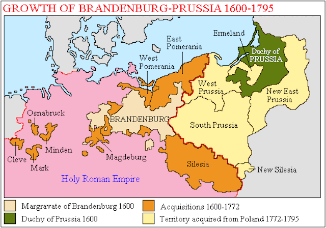
There were also South Prussia and New East Prussia for a brief period of time:

https://en.wikipedia.org/wiki/South_Prussia

https://en.wikipedia.org/wiki/New_East_Prussia

Map: http://versaillescentury.com/vc/wp-content/uploads/2016/11/prussiamap.gif

prussiamap.gif


http://www.zum.de/whkmla/histatlas/germany/prussia17951803.gif

prussia17951803.gif


As for (East) Prussia:

Warmia (Ermland) was incorporated to it in 1772, and later there were only minor border changes:

http://media.web.britannica.com/eb-media/19/119-004-D5B02134.gif

119-004-D5B02134.gif
 
Northern Poland includes the following 10-12 smaller historical regions:

1) Kuyavia - https://en.wikipedia.org/wiki/Kuyavia
2) Krajna - https://en.wikipedia.org/wiki/Krajna
3) Dobrzyn Land - https://en.wikipedia.org/wiki/Dobrzyń_Land
4) Chelmno Land - https://en.wikipedia.org/wiki/Chełmno_Land
5) Tuchola Forests - https://en.wikipedia.org/wiki/Tuchola_Forest
6) Kociewie - https://en.wikipedia.org/wiki/Kociewie
7) Powisle - https://pl.wikipedia.org/wiki/Powiśle_(region)
8) Lubawa Land - https://en.wikipedia.org/wiki/Lubawa
9) Kosznajderia - https://de.wikipedia.org/wiki/Koschneiderei
10) Area of former Free City Danzig (Wolne Miasto Gdansk)

And I'm not sure about these two (they are areas A and C in the map):

11) Pałuki (A in the map) - https://en.wikipedia.org/wiki/Pałuki
12) Marienburg-Elbing (C) region (also known as Żuławy / Werder):

http://www.nasze.kujawsko-pomorskie.pl/images/stories/etnografia/regiony.png

regiony.png
 
What do you think?

As for Lesser Poland, I added (Northern) and (Southern) in brackets, because I'm not sure whether we should leave it as one region, or whether we should divide into two.

But I'm inclined to leave it as one region.

Mlukas what do you think about Lesser Poland, should it be divided into 2 parts?
 
Kaliningrad Oblast will also be Prussia (eastern part, or north-eastern).

=================

Do you have any questions about my suggested division into regions?

I made that map in GIMP and borders of regions usually correspond to borders of counties from 1900 AD. Of course I took into account historical, cultural, ethno-linguistic etc. factors - not just 1900 administrative divisions.
 
Kaliningrad Oblast will also be Prussia (eastern part, or north-eastern).

=================

Do you have any questions about my suggested division into regions?

I made that map in GIMP and borders of regions usually correspond to borders of counties from 1900 AD. Of course I took into account historical, cultural, ethno-linguistic etc. factors - not just 1900 administrative divisions.
You are overdoing it. Do the basic known regions. Later regions should be adjusted according to genetic differences and similarities.
 
Back
Top