Incredible speed of colonization by First Farmers, EEF.

LeBrok

Elite member
Messages
10,259
Reaction score
1,618
Points
0
Location
Calgary
Ethnic group
Citizen of the world
Y-DNA haplogroup
R1b Z2109
mtDNA haplogroup
H1c
Whole Balkans were settled in just 300 years!

The traditional view of the Neolithic in the Balkan Peninsula involved the expansion of farmers out of the plains of Thessaly and northern Greece, moving up the natural corridors of the major river valleys with general northward and westward directions (11). However, more recent reevaluations of existing radiocarbon dates suggest that it is unlikely that Initial or Early Neolithic sites in Thessaly were established earlier than 6500/6400 calibrated (cal) B.C., many possibly later, between 6300 and 6100 cal B.C. (12, 13). Several recent accelerator mass spectrometry (AMS) radiocarbon dates for Early Neolithic communities in the central and northern Balkans suggest a rapid spread of farming communities as early as ∼6300/6200 cal B.C. (14,15). Resolution of various competing models strongly depends on evidence regarding human mobility in this region.

Strontium isotopes document greater human mobility at the start of the Balkan Neolithic
http://www.nature.com/ncomms/2014/141021/ncomms6257/full/ncomms6257.html

Farmers settled Thessaly around 8500 years ago and by 8200 they reached Danube Gorge. It is not about walking the distance, but producing surplus of people, looking for new agricultural grounds, bringing all the material culture with them, building new homes and villages, clearing land for farming, etc. These things take time. They produced enough people in 10 generations to settle around the Balkans from Greece to Hungary.

Furthermore:
There were also probably several chronologically separate events during which individuals from likely Neolithic communities interacted with and became incorporated into forager communities in the Danube Gorges in the centuries after ∼6200 cal B.C. Our study unequivocally proves that in the earliest phases of the Neolithic in southeastern Europe, perhaps paradoxically, farming communities were much more mobile than local foraging populations, which in the case of the Danube Gorges remained tied to the exploitation of particular ecological niches since the beginning of the Holocene up until ∼6200 cal B.C.

This process of asymmetrical acculturation ended up in a complete absorption of forager specificity in the first several centuries of the sixth millennium B.C.
 
6200 BC is unusual period. Little Ice Age ends (part of Younger Dryas) culminating with fast rise of global temperature and rise of sea level called Metwater pulse 1C in geological research. Europe warmed up enough to allow farmers to grow wheat here. That's the secret why they have spread swiftly through Europe after around 6,200!

Based upon solid geological evidence, consisting largely of the analysis of numerous deep cores from coral reefs, variations in rates of sea level rise have been reconstucted for the early Holocene. During this period of deglacial sea level rise, 3 major periods of accelerated sea level rise, called meltwater pulses, occurred. They are Meltwater pulse 1A between circa 14,600 and 14,300 calendar years ago; Meltwater pulse 1B between circa 11,400 and 11,100 calendar years ago; and Meltwater pulse 1C between 8,200 and 7,600 calendar years ago. The Younger Dryas occurred after Meltwater pulse 1A, which was a 13.5 m rise over about 290 years centered at about 14,200 calendar years ago and before Meltwater pulse 1B, which was a 7.5 m rise over about 160 years centered at about 11,000 calendar years ago.[7][8][9] Between Meltwater pulse 1A and Meltwater pulse 1B, the Younger Dryas was a interval of a significantly reduced rate of sea level rise relative to the periods of time before and after it. For example, the analysis of cores fromTahiti coral reefs found that sea level rose at a rate of about 7.5 ± 1.1 mm/yr during the Younger Dryas. Just after the end of the Younger Dryas, the rate of sea level rise accelerated to 17.4 ± 0.4 mm/yr and just before its start, it was 12.1 ± 0.6 mm/yr. This reduction in the rate of sea level rise directly reflected a substantial reduction of the global inflow of meltwater into the world's oceans during the younger Dryas.[7][10]

It is amazing how fast climate can change in matter of 100 years, and we can't blame people for this.
 
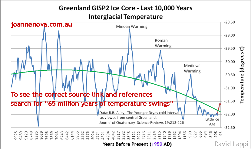
Here are historical temps from Greenland corroborating this 6,200 event.

gisp-last-10000-new.png


screen-shot-2015-05-23-at-07-39-06.png


Holocene_Temperature_Variations.png
 
check this : http://benthamopen.com/contents/pdf/TOGEOGJ/TOGEOGJ-2-1.pdf

the level of the Caspian Sea oscillates with every ice age
during glacial maximum the Caspian Sea shrinks ; during LGM it would have been 1/3 of present size
after LGM it started to swell from melting glacial waters discharged by the Volga river causing the Caspian Sea to spill over into the Blakc Sea, which was still a lake at the time
 
after LGM the ice sheet in West-Northern Siberia obstructed the flow of the Yenessei and Ob rivers
the whole West-Siberian plain was flooded
and would have spilled over to the Aral Sea, which in turn spilled over into the Caspian Sea (this last part is speculation, it is not proven by geological deposits)

http://www.folk.uib.no/ngljm/PDF_files/Mangerud-et-al01.pdf
 
check this : http://benthamopen.com/contents/pdf/TOGEOGJ/TOGEOGJ-2-1.pdf

the level of the Caspian Sea oscillates with every ice age
during glacial maximum the Caspian Sea shrinks ; during LGM it would have been 1/3 of present size
after LGM it started to swell from melting glacial waters discharged by the Volga river causing the Caspian Sea to spill over into the Blakc Sea, which was still a lake at the time
And the Black Sea was spilling over to Mediterranean Sea, but not vice versa like today. Could be a reason why farmers couldn't cross from Anatolia during big melts. Caspian and Black Lake (not a sea yet) were huge and spilling with a big river to Mediterranean with no passages left. Either it was too cold to do wheat in Europe or melt water was blocking the entrance. Tough luck, lol.
 
Here is a nice chart:

14nziq1.jpg


Interestingly when the big chill came around 6300 BC in Greenland, Antarctic had huge warming spike.
 
And the Black Sea was spilling over to Mediterranean Sea, but not vice versa like today. Could be a reason why farmers couldn't cross from Anatolia during big melts. Caspian and Black Lake (not a sea yet) were huge and spilling with a big river to Mediterranean with no passages left. Either it was too cold to do wheat in Europe or melt water was blocking the entrance. Tough luck, lol.
I wouldn't think so, as they were able to cross to Cyprus and Crete, the Bosporus or the Dardanelles can't have been a problem.
Moreover I think this spillover happened some 11.000 years ago (right after the youngest dryas)
 
Last edited by a moderator:
I wouldn't think so, as they were able to cross to Cyprus and Crete, the Bosporus or the Dardanelles can't have been a problem.
Obviously they knew how to build boats, you are right. What then was holding them for 1-2 ky in Anatolia and Cyprus and didn't let them expend into Greece? Even when it was colder, Greek climate should have been similar to Anatolian. So why didn't they expend sooner?
Moreover I think this spillover happened some 11.000 years ago (right after the youngest dryas)
I think it was spilling all the time till temps stabilized by 10 kya, then maybe it spilled again during 6,200 BC big melt event which led to rise of Ocean levels till it caused Black Sea deluge around 5,600 BC.
 
Back
Top