• Don't want to see ads? Install an adblocker like uBlock Origin or use a Europe-based privacy-friendly browser like Vivaldi or Mullvad.

Neolithic Refuge and Continuity in Transylvania

To me, the most promising sampling for a potential E-V13 + J-L283 population in the Balkans so far comes from the Timacum minus site. As for the Dardanians, we just need to get them sampled. Concerning the Srem region/group(s), there were multiple layers and movements, some of which appeared to be strongly North Thracian shifted, while later we get samples which appear to have very little such influence.

The Scordisci are a force to consider however, especially since we got these samples from the Sarmatian era, from the Southern Tisza-Danube zone, where we see this rather Central European-mixed profile with a significant regional frequency of E-V13, going by the currently available samples.
 
What I found stri
Since the BBC samples from Croatia are late Roman period, I think it warrants an update on the stats of Roman provinces based on ancient DNA published to date:

wwGTERn.png


The patterns are self-evident. There are two weaknesses to the data. The current Dalmatian data is heavily biased on cosmopolitan sites(which is normal for Roman Dalmatia), and so is the Serbian data, which comes almost entirely from Viminacium. It is what is, the data is still valuable.
What I found striking is the North-South opposition between Y-E-V13 and Y-J2b-L283.
 
What I found stri

What I found striking is the North-South opposition between Y-E-V13 and Y-J2b-L283.
That's kind of misleading, because only Croatia being counted. In Hungary, E-V13 is totally dominant vs. J-L283. Croatia was, by and large, an Illyrian country, therefore E-V13 appeared mostly with certain expansions in Croatian territory, like at the peak of Channelled/Stamped Ware, with the expansion of Eastern Celtic elements which had E-V13, and with late Greek and Roman settlements and migrations, especially along the coast - and later with the Vlachs etc.

It is not that E-V13 is generally more Southern, but generally more Eastern. And along the Danube, E-V13 spread more than J-L283 also. Here is a map for Daco-Thracian vs. Illyrian plus the purple contact zone of interaction/possible mixed groups:
Map-Thracian-vs-Illyrian-a.jpg


If you look at that map, it is clear that E-V13 wasn't common in Iron Age Croatia. The locals were mostly Illyrians and therefore dominated by J-L283. Only in the Northern fringe and in the coastal zone E-V13 is more likely to have appeared, by direct Daco-Thracian contacts and some migrations, including later Greco-Roman movements from the East.
To the North of Croatia, in Hungary, the Daco-Thracian dominance at the Danube and Tisza zone clearly shows.
 
On the topic of E-V13 and Daco-Thracians, I still think this is the most well studied chronologically, at least i agree with most of it regarding MBA-LBA-EIA period. It looks like a solid well studied homework.

Belegis-Gava II is included as distant cousin and potentially heavy E-V13 to Daco-Thracians, and the actual Gava-Holigrady was a result of Belegis-Gava II people moving and migrating northwards to Carpathians. At least that is how i understood.

GrVKZdjWYAA3hAx


He suggests that during EBA Daco-Thracian E-V13 have their origin in Banat, could be true, but could also not, every Balkan or especially the more dynamic Balkan-Carpathian Cultures reaching to Chalcolithic-EBA are so dynamic, so complex that it is very hard to pinpoint what was going on.

On this part, I am not entirely sure what was the real deal. But, one can reverse engineer atleast up to Middle Bronze Age approximately.
 
The issue here is that we know for sure that Nyírség, Wietenberg, Verbicoara-Tei etc. were clearly related and influenced each other.
Critical for the North is how exactly the transition from Otomani and Wietenberg to Suciu de Sus took place and whether Eastern Otomani had Southern influences.
That the Southern Gava-related Belegiš II-Gava/Susani and Vartop groups were E-V13 is to me a given fact. Both most Northern Gava and Zimnicea-Plovdiv-Cerkovna are very likely but less sure by comparison. Without the Southern Gava-related groups the whole distribution and dispersion for the later periods and groups would be much more difficult to explain.
 
Abstract of the upcoming EAA are out:

521. GENOMIC STABILITY AND TRANSFORMATIONS IN PREHISTORIC TRANSYLVANIA

Since prehistory, Transylvania has long been a landscape characterised by rich natural resources, fertile farm-
ing land and relative protection from the surrounding Carpathian and Apuseni Mountains. However, the genetic
history of the people that have inhabited Transylvania is poorly understood, with the archaeogenetic record
previously represented by only a few individuals. Conversely, the history of the regions in southeastern Europe
surrounding Transylvania are well studied, and attest to dramatic genetic turnovers accompanying the change
from a hunter-gatherer to a sedentary agricultural lifestyle, followed by the arrival of steppe-related ancestry
with the expansion of pastoralist societies from the steppe zone east of the Carpathian Mountains. In this study
we report archaeogenetic results from individuals from Transylvania and the surrounding regions in Romania,
from a period spanning the Neolithic to the Late Bronze Age. We report a surprising level of genetic continuity
within Transylvania, with little evidence for an influx of steppe-related ancestry into individuals associated with
the main cultural groups until the Middle to Late Bronze Age. We also find evidence for Yamnaya and Yamnaya-
related groups dating to the Early Bronze Age who, however, appear to have left only subtle genetic footprints in the
region.
In stark contrast, steppe-related ancestry is only widely introduced with the Late Bronze Age Noua groups.
In summary, we find that while Transylvania was at times a melting pot of genetic profiles, the region still main-
tained an ongoing thread of a continuous genetic legacy during the Copper Age and for much of the Bronze Age.

Note the exact wording, which suggests that there was steppe influx and gene flow from the earliest samples after steppe contact (e.g. Yamnaya), but that the total impact was very low. And again, very important is that the increase of steppe ancestry (to which extent?) in the MBA-LBA with Füzesabony and Noua-Sabatinovka might have been more transient and elusive, largely reduced or disappeared soon after, in Gáva-Holigrady - if ever reaching the groups of relevance (like Suciu de Sus, Igrita, Cehalut, Berkezs-Demecser etc.) which all cremated and were not properly sampled.

In any case, it is very important to stress that Transylvania might have been a true reservoir of a very EEF-rich population, possibly even more so than say much of Bulgaria, from which we got some samples, from different cultures and periods, which look quite different in this respect.

Also of possible interest, depending on exact sites sampled:

2308. THE INHABITANTS OF EUROPE’S MEGAFORTS IN CONTEXT: NEW POPULATION GENETICRESEARCH IN THE SOUTHERN PANNONIAN PLAIN

The rise of a new settlement network in the 15th century BCE in the southern Carpathian Basin termed the lower
Pannonian network represented a dramatic change in the social dynamics of the region, with population expansion
driving the establishment of numerous settlements in previously underpopulated areas. This network included
several megaforts - sites of unprecedented scale and complexity. It remains unclear whether this massive growth
in settlement numbers and scale was driven by internal demographic changes, such as shifts in family structures
and mortality rates, or by external immigration. Cremation was the dominant burial rite, though inhumation
burial is also known in cemeteries associated with these fortified sites and at other cemeteries in their hinterlands
associated with different ceramic traditions. This provides a limited, but important, corpus of material suited
to genetic analysis. The lower Pannonian network emerged following the collapse of the preceding socio-politi-
cal model of the Middle Bronze Age ca. 1550 BC, centred around tells and tell-like mounds. After its collapse ca.
1200 BC, there was a period of low-density occupation in this same area, until the emergence of a new horizon of
smaller enclosed sites between 1000 and 900 BC.
To contextualise the rise and fall of this network, we have gath-
ered genetic data from these three horizons and from neighbouring areas, which are co-analysed with published
data. We discuss newly generated genomic data from 80 individuals from 22 archaeological sites in the Pannonian
Plain and Dinaric Alps
. Preliminary results are used to characterise population continuity and diversity, kinship
structures, and shifts in societal organization across key transitions, including the collapse of Middle Bronze
Age tell-centred networks, the rise and fall of the megafort horizon, and the transition into the Early Iron Age.

This will definitely shed new light on Encrusted Pottery and Vatya remains, on the Koszider horizon/spread of Tumulus culture - with possible contact zones to the cremation group/later Gáva-related East.

For a perspective on Albania/Southern Balkans, mainly Kamenice:

687. NEW ARCHAEOGENETIC INSIGHTS INTO THE ALBANIAN BRONZE AND IRON AGE

Situated at the interface of the Aegean and the Adriatic in southeastern Albania, the Kamenice Tumulus func-
tioned predominantly as an inhumation burial site from 1700 to 500 BCE. This stands in contrast to the prevailing
cremation rituals observed in Central Europe during the same period, which have typically impeded insights
into archaeogenetic progressions. In this work, we generated genome-wide SNP data for 230 individuals buried in
Kamenice over its complete historical span, alongside 19 Iron Age individuals from North Macedonia and 2 Late
Bronze Age individuals from southwestern Bulgaria.
Our comprehensive dataset provides the unique and first
possibility for insights into, on the one hand, genetic continuities and changes of Late Bronze Age and Iron Age
Albania; on the other hand, the function and meaning of tumuli in prehistoric Europe. Different societal trans-
formations identified in the wider region are associated with a genetically stable and genealogically continuous
population at Kamenice. Our results indicate that the local population maintained a distinct genetic profile while
participating in a regional kinship network extending over 300 kilometers, as demonstrated through identified
biological relatedness up to the 10th degree. Moreover, for the first time, we found evidence linking a partial turn-
over of male lineages around 750 BCE in a patrilineal society to a substantial shift in the structure and material
symbols of the tumulus.

New big batch of Avar (and possibly Gepid) era samples from an area which is highly likely to have had E-V13 carriers:

2237. IMPRINT OF SOCIAL, CULTURAL AND ECONOMIC CHANGES WITHIN THE AVAR EMPIRE. THE
TESTIMONY OF THE KÖLKED SITE


A multidisciplinary study of one of the key sites for understanding the background of diverse, varied material
culture of the late 6th - 7th centuries in the Carpathian basin has provide. an insight view into a community,
which had strong and intense connections with the late antique Mediterranean but even closer relations to the
Meroving West and to the former Germanic traditions of this territory. In Kölked-Feketekapu 1325 burials
and
five hectares (with more than 500 features) of the community’s settlement were excavated, which could provide
a representative section of the Carpathian basin’s social, cultural and economic history between mid-6th - early
9th century AD. Distinctive household system within the settlement and West European type of long houses are
unique in the Avar Empire. The circular ditch system presumably for rituals and jurisdiction practices tied to
Germanic costumes were observed in the Early Avar period. A Reihengraberfeld and separate burial grounds
within the household units belonged to this settlement. A complete change was detected during the last third of
7th c.: the settlement structure, the burial costumes, and even the physical place of the cemeteries were affected.
Discernible acculturation and assimilation processes and newcomer communities of different original traditions
living side-by-side in the later era, complemented the effects of a social, economic and possibly political change
visible all over the Avar Empire as well. Ancient DNA and isotope analyses (360 aDNA, 121 87Sr/86Sr, 75 δ13C -
δ15N samples) within the framework of the ERC HistoGenes project complemented the classical archaeological
study of the burial rite and grave goods, which were integrated with household archaeology and physical anthro-
pological research. Kölked provides an unpaired possibility by interpreting and understanding the transitional
processes in both burials and settlement with enlightening the forming forces behind them and the organizing
factors of these changing societies.

360 samples is quite a number. I hope the coverage is good. Because its an early transitional site, we might be able to get a better understanding for the E-V13 lineages' origins in the Avar context.

This paper might include E-M35/E1b1b samples:

1861. TEETH IN TRANSITION: ODONTOMETRIC ANALYSIS OF MESOLITHIC HUNTER-GATHERERS AND

NEOLITHIC AGRICULTURAL COMMUNITIES IN THE DANUBE GORGES (9500-5500 CAL. BC)


(Department of Archaeology, Faculty of Philosophy, University of Belgrade)
The Mesolithic-Neolithic transition is one of the most significant processes in human history, profoundly impact-
ing human biology, health, and dietary choices. During this transformative period, communities shifted from
hunting and gathering to a sedentary, agricultural lifestyle, further influencing human development. In many
regions, the transition to food production was accompanied by a reduction in craniofacial and dental dimensions.
In this study, we investigate whether the Neolithic transition affected tooth dimensions in the Central Balkans, a
key area for examining Neolithisation due to its strategic position at the crossroads of the Near East and Europe.
To assess this, an odontometric study was conducted on the teeth of Mesolithic hunter-gatherers and the newly
arrived Neolithic population in the Danube Gorges (9500–5500 cal. BC). To investigate potential differences in
odontometric parameters between these two groups, we measured the mesiodistal and buccolingual diameters
of permanent maxillary and mandibular molars using an optical digitizing device. Our sample includes individ-
uals from Padina, Vlasac, Lepenski Vir, and Hajdučka Vodenica, for whom absolute dates and aDNA genotyping
data are available. Previous studies enabled us to genetically determine whether individuals belonged to the hunt-
er-gatherer or agricultural population. By comparing tooth size between these groups, we aim to reconstruct how
the mixing of populations, lifestyle shifts, and dietary changes affected teeth dimensions in the Danube Gorges.

Could be of interest:

1624. PECULIARITIES OF THE DENTITION IN HUMAN SKELETON SAMPLES FROM IRON AGE SITES I.

SOUTHEAST ROMANIA


The human skeletal remains discovered in sites of both Early and Late Iron Age, on the territory of Romania, are
relatively few, due to the widespread practice of incineration, which led to the damage of the bone material and
poor preservation. A such situation creates gaps in the knowledge on archaeological human populations in terms
of biological characteristics and evolution in this region. This study aims to reevaluate human skeletal remains,
which date to Iron Age, discovered in Southeast Romania
, with a particular emphasis on the dental analysis. By
investigating morphological dental patterns, and pathologies, this work contribute to better understanding of the
genetic diversity and health status of the Iron Age people in the specified region. The dental material analyzed
here belongs to adult skeletons recovered from bi-ritual necropolises: Enisala, Histria, and Isaccea. The exam-
ination of morphological dental patterns focused on the occurrence and expression degree of non-metric traits,
on the surface of the teeth. Specific features were identified in the development and expression of the metacone
and hypocone cusps on the upper molars, the presence of accessory tubercles on canines, the Carabelli trait, as
well as the angular torsion of the mandible. Dental pathologies such as hypoplasia, granuloma, and tooth loss
suggest possible dietary deficiencies. Another significant aspect is represented by the presence of caries and the
absence of dental calculus, which could indicate a predominant consumption of foods producing oral acidity.
The results of this study provide clues to understand how these human groups adapted to environmental condi-
tions, diet, and lifestyle, highlighting aspects of both biological evolution and cultural practices that influenced
their oral health. This work was supported by a grant of the Ministry of Research, Innovation and Digitization,
CNCS–UEFISCDI, Funerary landscapes in the Carpatho-Dniestrian area at the beginning of the Late Iron Age,
PN-IV-P2-2.1-TE-2023-0015.

Would be great to get genetic data from more samples from this region.

Interesting paper on Late Antiquity early Medieval Central Europe:

929. CHALLENGING TRADITIONAL MIGRATION PERIOD NARRATIVES WITH A MULTI-PROXY APPROACH

The 1st millennium CE in Basel (Switzerland) is characterised by diversity in the archaeological record and complex
political, cultural, and economic interactions. The present study aims to investigate mobility patterns, subsistence
strategies, and communication networks in the region at the periphery of the Late Roman Empire, which became
the centre of Early Medieval crossroads between cultural entities. This objective is pursued through an in-depth
analysis of ca. 150 burials dating to the 4th to the 8th centuries CE using an integrative approach encompassing
AMS radiocarbon dating, archaeological, anthropological, isotopic, and genetic analyses, as well as environ-
mental modelling.
Preliminary results call into question the previously held view of large-scale migrations from
the 4th/5th centuries onwards. Instead, the results indicate that regional mobility was prevalent – besides the
presence of large-scale communication networks. This study underscores the pivotal role that bioarchaeological
approaches play in unveiling hitherto unanticipated facets of social dynamics during the late antique and early
medieval periods in Basilia/Bazela, thereby facilitating the reconstruction of individual life histories. The study
further demonstrates the benefit of integrating multivariate models involving high-resolution climatic and envi-
ronmental data to disentangle potential drivers of isotope variability at various scales.

Source: https://www.e-a-a.org/EAA2025/Progr...e6e2-4424-8e18-beddd8e526f7&Program=4#Program
 
The new Romanian samples are both Babadag and Scythian era, however keep in mind that this paper involves Romanian archeologists, so far we have gotten all sorts of DNA samples from Romania as long as they are not from Daco-Thracian periods, I don't have much hope in seeing the results get published any time soon. A common theme that has to be acknowledged.
So an abstract is just that an abstract. Maybe the data will get published after WW III.
MrcUkqe.png
 
Here another view on the same issue:

map-of-the-Yamnaya-area-base-map-Cezar-Buterez-map-of-mounds-investigated-in-Romania.jpg


Some Kurgans were used by Cotofeni people though, but still, one can see that the main area of local survival practically without intereference is the later core area of Nyirseg into Eastern Otomani-Western Wietenberg into Suciu de Sus-Cehalut into early Gáva. It is nearly always the Hernad valley, Nyirseg region, Somes region, all the areas East of the Tisza and North of the Apuseni mountains, plus in the South the highlands and much of the Körös area. The same can be later said about Mezocsat and Ciumbrud group, the steppe intrusions in the Early Iron Age. Again the locals persisted East of the River, North and South of the Apuseni mountains, whereas the Transylvanian lowlands were more mixed with the foreigners. Oltenia has some Yamnaya kurgans, but only in the very South West. The highlands are, like in Nyirseg, "Yamnaya free". You can therefore draw the classical kind of banana shaped zone which is absolutely crucial for the local survival. I made it myself on the above map:

Edition-of-the-map-of-the-Yamnaya-area-base-map-Cezar-Buterez-map-of-mounds-investigated-in-Romania.jpg


The dark blue zone, especially the one North of the Apuseni mountains, is the absolute core zone of local survival through the ages. Most groups being stopped there (Yamnaya, Kisapostag-Encrusted Pottery, Kostany-Füzesabony, Noua-Sabatinovka, Tumulus culture, Cimmerians, Scythians, Celts, Sarmatians - even the Romans had their difficulty establishing themselves in the blue zone North of the Apuseni mountains and quickly left.

Here another map, note the Nyirseg zone - "Yamnaya-free":

The-distribution-of-the-mound-sites-from-western-Transylvania-and-Romanian-Banat-and-the.png


Upper Tisza area is basically without Yamnaya presence. It is the the very North Eastern part of Hungary and all the adjacent areas of Romania into the Somes valley etc. They are practically without Yamnaya interference. The same can't be said about all of Transylvania and the situation mirrors exactly the pattern of Sanislau-group of Vekerzug and Kustanovice vs. Ciumbrud group and Scythian influences. In the Iron Age too, the Scythians did disturb and influence the Northern locals, but they didn't replace them - in fact, the mixed Scythians were replaced by the locals subsequently, as the abstract on Iron Age Transylvania Ciumbrud group and La Tene era people has shown - again by a Balkan-like people. The same happened in the Yamnaya area too. The locals did take up some Yamnaya customs (like in Copaceni and Livezile), but the long term influence was small and the Yamnaya people being replaced from the riverlands and highlands.

Again, like if they have used a "Yamnaya repellent" in Nyirseg: The border is absolutely strict. Note how many kurgans appear West of the Nyirseg zone, whereas practically none are in the Eastern part.

And even the tumuli there are, many are of local origin:

The presence of the pre-Yamnaya tumuli burials was
already underlined in the western territory of the Yamnaya
Culture, but for the area west of the Carpathian Mountains,
only two sites from Hungary were highlighted (Sárrétud-
vari and Tiszavasvári)106 based on their respective stages
of research. The research from Silvașu de Jos-Dealu
Țapului certify the presence of this pre-Yamnaya earthen
tumuli horizon also in the southwestern part of Transyl-
vania, exhibiting cremation and Coțofeni III-style pottery
,
the same rite aspects appearing also in Bucova Pusta IV107,
where an infant cremation burial is connected to a
Coțofeni bowl108. Thus the observations from the Trnava
tumuli, level II (graves nos. 2 and 5), are strengthened
and the discussion about the cultural attribution of the
Coțofeni III assigned graves from tumulus no. V/1975 from
Cheile Aiudului-Dealul Velii109 or grave no. 2 from Livez-
ile-Dealul Sîrbului110, both of these barrows being char-
acterised by stones coverings, is re-opened. The presence
of the Coțofeni-style pottery from Romanian Walachia in
inhumation grave no. 3 from Ariceștii Rahtivani IV111, 14
dated to 3340–3010 calBC (93.9 %) in very good correla-
tion with the Coțofeni phase of the tumuli from Silvașu de
Jos, underlines the fact that this pre-Yamnaya horizon of
tumuli burials uses Late Eneolithic pottery also in western
Transylvania and Romanian Banat, similarly with what is
observed north of the Lower Danube, where Coțofeni, Cer-
navodă II, Foltești, Usatovo, Gordinești and Ezero types of
pottery are used as funerary inventory
112. The same situa-
tion can be underlined also north of the Black Sea, where
the Usatovo group is characterised, among other things, by
the tumulus cemeteries113. In the same geographical and
chronological frame can be positioned the tumuli of the
Životilovka grave type114, where the presence of Gordinești
(Kasperovo) pottery is a common element115. This horizon
also appears in Bulgaria, Serbia and Hungary116, labelled
as Period II in the Hungarian chronological system devel-
oped within the last century117.

Also note the dating. It coincides with the earliest E-V13 branching.
Surely E-V13 was still a minority back then, but might have spread with the Pre-Yamnaya tumuli of the Cotofeni culture for the first time.

Unlike Nyirseg, parts of Western Transylvania were not "Yamnaya-free":

Classical Yamnaya Culture (stage five here or
Period IV124) discoveries are spread west of the Black Sea
according to the already-asserted opinions125, corrobo-
rated by corded pottery, generally associated with the
steppe area, or with local style of pottery126. The discov-
eries presented above offer the opportunity of also includ-
ing the Romanian Banat and western Transylvania regions
into the Yamnaya territory. It is important to underline that
the present sites from this area assigned to this culture are
connected to the lower and middle Mureș valley indicating
that this river is, most likely, the pathway towards Tran-
sylvania.

That's what we see in the Mures culture later, too, that they have more steppe/even actual Yamnaya influence (R-Z2103!). The locals to the North and East don't.

Source: https://www.researchgate.net/publication/342076534_Step_by_Steppe_Yamnaya_culture_in_Transylvania

Therefore if talking about the local survival, even in those regions where the locals took up some Yamnaya customs, like they did in Capaceni and Livezile groups in Transylvania, the core of the locals must have lived in blue zone. However, since the paper explicitly talks about weak Yamnaya influences, we can assume that even those groups which did take up Yamnaya cultural influences, had low levels of steppe admixture.
The steppe admixture must have been very low, since the neighbouring groups have no excessively high levels either. Therefore if the Transylvanian/Transtisza core sticks out, by comparison, the steppe admixture must be quite low indeed and shouldn't exceed 30 % in any case - but rather being lower still. Otherwise the conclusions drawn in the paper make no sense.

It is very, very important to stress that the blue zone North of the Apuseni mountains was only taken away from the Daco-Thracians the last, basically only between 2nd-5th century, when the Germanic tribals and finally the Slavs moved in.

Here is the Roman occupation of the zone:

Map-of-Roman-Dacia-after-the-administrative-re-organization-of-Hadrian.png


The Romanised inhabitants must have been primarily of Dacian origin, especially in the rural zone.
 
Last edited:
This dichotomy in the Carpathian basin's East has a topographic reason:

Topographic-scheme-of-the-Tisza-River-Basin-The-Carpathian-Mountains-form-an-arc-along.png


Source: https://www.researchgate.net/figure...an-Mountains-form-an-arc-along_fig1_237475823

Yamnaya was centered in the lowlands, see the darker green, whereas the locals centre, like I mapped it above, was at higher elevation in lighter green into the yellow highlands. You can also see, how the Maros river creates a pathway into Transylvania South and East of the Apuseni mountains, where both Yamnaya and Scythians did move along, but also the Maros cultural group (with Yamnaya influence).

The Upper Tisza being a structured area, structured by rivers and swamps, at higher elevation and with a more sandy soil. That's not good territory for classical steppe pastoralists and the locals did specialise there. The very area were Slovakia, Hungary, Ukraine and Romania border each other, that's the largest area which was inhabited by locals in nearly all periods. And its also the centre for both Nyirseg-Sanislau culture, Eastern Otomani, Suciu de Sus and later Gàva. This is also a core area for Cotofeni and Makó in earlier periods. Therefore since the late Copper Age we deal with a Pre-Yamnaya steppe influenced (Usatovo-Gorodsk and Cernavoda connections) people which persisted into the Roman era the least, likely up to the late Germanic-Avar, possibly even into Slavic era.

Here is the Northern core zone (for the Southern refuge the earlier map, its basically Northern Oltenia and its neighbourhood):

Edited-Topographic-scheme-of-the-Tisza-River-Basin-The-Carpathian-Mountains-form-an-arc-along.png


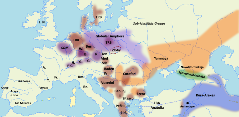
What Yamnaya and the other steppe groups often did, was basically cutting the local sphere in half, into a Northern and a Southern one. Early Cotofeni core:

2700-768x378.png


Yamnaya runs right through it, pushing the Cotofeni and related groups both North (Upper Tisza) and South (Oltenia) into their zones of retreat, resulting in Nyirseg (North, with Vucedol influences) and Glina-Schneckenburg (South), plus small regional groups which had varying degrees of Yamnaya influence (like Copaceni, Livezile etc.) in Transylvania in the middle.

The same area (where Slovakia, Hungary, Romania and Ukraine border each other respectively) was continuously inhabited by:
Cotofeni -> Nyirseg/Sanislau -> Eastern Otomani -> Suciu de Sus -> Lapus -> Gáva -> Sanislau group/Eastern Vekerzug -> La Tene influenced North Thracians -> Dacians

All these groups were mostly or even strictly cremating their dead.

Number 6 is the Nyirseg culture:

images


Number 7 is the Maros culture, which emerged right in the area into which Yamnaya broke into along the Maros river and being, while in contact with the locals (Proto-Nagyrev and Nyirseg, emerging Wietenberg being not shown, but to the East of Nyirseg) clearly distinct - though not as differentiated, by comparison, as the Kisapostag-Encrsuted Ware people to the West (4).

It is, in any case, amazing how archaeological records and genetic results align. Because again, no clear Yamnaya intrusion ever changed the Nyirseg and the Northern core zone I outlined. Plus even the tumuli which appeared, unless they were in the clear Yamnaya zone, like along the Maros river, were mostly done by locals of Cotofeni origin.
This explains why the high EEF locals persisted. Archaeological results already told us so.

Note there is a zone East of the Tisza which was taken by Yamnaya, but they didn't move through what is now the Hortobágy river and national park: https://www.wikiwand.com/en/articles/Hortobágy_National_Park

This is an excellent territory for pastoralists, directly to its East starts the Nyirseg: https://de.wikipedia.org/wiki/Nyírség

Also some ideas on the emergence of Cotofeni, which is the main candidate, the second being Vucedol:

The question of the origin of the Cotofeni culture should be viewed
within the framework of the emergence and expansion of Boleraz-Cernavoda
III and, for a somewhat later period, of Baden, as well. Numerous elements of
Cotofeni pottery, especially as found at Romanian sites, derive from the style
of Cernavoda III
: the use of plastic bands, a rather coarse version of the
herringbone motif, and broad channelling. This kind of pottery from Romanian
sites (Petresti, Brateiu-NiSiparie, the earlier layers of Locusteni) 209 is dated by
P. Roman to phase I of the Cotofeni culture. This phase is also characterized
by the complete absence of Furchenstich decoration and of the motif of cuts
organized into chequer patterns in Kostolac manner (Herculana-Pestera-
Hotilor, Girbova de Sus).210 The presence of Boleraz-Cernavoda III elements
in the early phase of Cotofeni does not indicate, however, a direct evolution.
The Cotofeni culture probably came into being as a result of the very same
process which gave rise to Baden in the Pannonian Plain. Only their
autochthonous bases were different: in the case of Baden, the line followed was
Balaton-Boleraz-Baden, while the basis of Cotofeni was a combination of
Cernavoda III and Salcuta.


That idea is interesting, since Salcuta is more Southern than Tiszapolgar-Bodrogkeresztur, Petresti and Ariuszd/Tripolye-Cucuteni, which I consider more likely to have made the contacts with the steppe groups and evolve with E-V13.

But to elaborate on that, here some information on Salcuta:

About the Sălcuţa Eneolithic culture. The name of the Sălcuța eneolithic communities comes from
the eponymous settlement in Dolj County. The area in which it spreads comprises Oltenia, eastern Banat, north–
western Bulgaria, north–eastern Serbia, similar communities also being found in Macedonia and Albania.
Sălcuţa culture is part of a big Eneolithic complex, along with the Krivodol (Bulgaria) and Bubanj (Serbia)
groups. The best analogies for material culture elements can be found in Gumelniţa culture, phase B1.
Anthropomorphic plastics are well represented, along with copper tools. Sălcuţa communities’ evolution spans
over a three phases period, their ending being determined at the level of Herculane II-III – Sălcuţa IV cultures.

Needless to say we only have samples from Tiszapolgar-Bodrogkeresztur and Tripolye-Cucuteni/Usatovo-Gorodsk so far, with all sampled groups of relevance yielding E-L618 samples, proving the distinct possibility of an E-L618 centre nearby. Both Tiszapolgar-Bodrogkeresztur and Varna E-L618 samples were not related to the main group members sampled in the locality, making it possible they come from another group in the wider region.

Another interesting aspect is that we have Salcuta -> Cotofeni -> Glina-Schneckenburg -> Verbicoara-Tei -> Zimnicea-Plovdiv -> Bistreta -> Vartop-Gáva -> Basarabi in the same region (Oltenia). And again, if there is a region which can compete with or complement the Northern core, it is primarily Oltenia.

From Salcuta we have skeletal remains, which resemble Yamnaya-variants the most, which makes their affiliation dubious:

The anthropology analysis (A. Comșa,
1995) to an individual human being from M4
illustrated the robustness at the entire skeleton
level and well muscled. The sex is male, aged 40-
45 years old and the type is protoeuropoid with
northern influences
. The highest affinities are at
tumulus graves with red ochre populations. We
cannot speak about an allogenic, since the
anthropological type is very present in the
Romanian space at Neolithic level.

On the other hand, similar characteristics were found by the E-L618 carrier from Usatovo-Gorodsk.

Contacts to Tiszapolgar-Bodrogkeresztur are very possible, since they have similar burial customs:

Most graves are east-to-west oriented, head facing east and feet to
the west with a slight deviation to east/north/
east-west/south/west. The most obvious analogies
can be detected in Bodrogkeresztur culture and
also in Tiszavalk, Magyarhomorog, Tiszapolgar,
Basatanya, Jászladány cemeteries.

Therefore contacts/similarities to the very people tested from the Tisza zone in the Eneolithic which had some, possibly migrant, E-L618 samples!

The ethnogenesis with steppe influences:

Undoubtedly, the Eneolithic cemetery from
Ostrovul Corbului (P. Roman, 1996) is one of the
most spectacular discovery on Romania’s
territory and portrays a phenomenon of local
culture synthesis which reflects a predefined
symbiosis of earlier ethno-cultural contacts,
which,according to the inventory, were located
in the Sălcuţa-Tiszapolgar-Cernavoda I.

The site in South Western Romania, Oltenia:

Some irregular burials appeared:
In addition to these elements, practices which
cannot be classified as funerary were also attested
in the Sălcuţa area, such as human bones
occasionally discovered in domestically contexts.

They practised a strict gender/sex division:

Recent researches carried out in the southern
end of Lîga village (K. Randsborg et al., 2005) in
Bulgaria revealed seven tombs attributed to the
Krivodol group. All tombs were discovered in the
southern or south - western part of the Lîga hill.
Women were buried separately and children were
placed along with adult males. This division by
gender was also observed in a cemetery from the
Eneolithic period at Târgovişte (Bulgaria)
, where
11 graves were found out of which four were
attributed to men and another four to women. The
graves were placed separately.

Source: https://www.researchgate.net/publication/359459633_About_the_Salcuta_Eneolithic_culture

Since Cotofeni has a centre in Oltenia, from which it spread, this scenaro of a Salcuta - Cernavoda fusion is a viable one, which can be considered for its origins. But again, I'm not as sure about the origin of the E-V13 ancestor before the steppe formation, but I'm pretty sure about its origins in the Cotofeni - Northern Vucedol sphere in the later Eneolithic period.
 
Tizsa begins in the district of Rhakiv, which is entirely Hutsul populated, to this day it remains a E-V13 stronghold. Just pointing that out for Aspirin.

dGrSh2Y.png
 
Have you guys seen Spark'z Spartacus series? Despite some of its shortcoming like graphics, overly sexual, some other decisions i still find it an amazing story about the Thracian Gladiator turned rebel. Most of his followers though were Gauls and Germanics, since majority of Daco-Thracians were still independent from Roman rule. Spartacus apparently was a soldier in Roman army turned desertor and ended up enslaved as punishment and eventually a gladiator.

Spartacus came from Maedi/Satrae/Bessi tribe.

Tragic end to the original leading actor. That's what I remember the most from this series.
 
Here I present my current model for the Carpatho-Balkan cremation blocks evolution and network:

Carpatho-Balkan-block-genealogy.jpg


Note that red can both mean potential primary ancestry (just less likely), major or minor ancestral influence, or contemporary influence. Anything more refined would have been too complicated to depict graphically.

Crucial is that the whole Carpatho-Balkan block has two/three starting/end points:
1) Cotofeni and Vucedol as the main ancestral sources
2) Gáva-related Channelled Ware/Stamped Pottery out of it as the main end point which unified the whole sphere and potentially erradicated most invaders (like Sabatinovka, Encrusted Pottery etc.) and minor groups (those which might have been the secondary/non-E-V13/non-Thracian groups).

Essentially this means: The main E-V13 ancestor and clan first survived in either Cotofeni or (Northern/Eastern) Vucedol and Gáva-related Channelled Ware was either completely or largely (Possible but less likely alternative scenario: Only in the South or East?) dominated by E-V13.

In any case, everything considered, there is no way that E-V13 could have been thriving, as it did, outside of this Carpatho-Balkan cremation block. If it was restricted to one sphere (say Verbicoara-Tei), that's possible, even if its less likely, but any group outside of this wider block can be firmly excluded.
 
Last edited:
Tragic end to the original leading actor. That's what I remember the most from this series.

Yeah, Andy was great on his role as Spartacus. Unfortunately cancer took his good years, may he rest in peace. His replacement was good as well.

I think the series with a bit of tweaks would have been one of the GOAT TV Shows, overall major historicity events are on point, of course they took liberty on some/many details but that's totally fine still, expected for dramatic reasons.
 
On the Ciumbrud group, from which we know the local Balkan-like population of North Thracians persisted first in the mix and later replaced the Scythians:

The total known data set reaches some 300 graves. They are generally flat supine inhumations, although there are also some bi-ritual cemeteries (e.g. Băiţa (Babeş & Miriţoiu 2011) and Uioara de Sus (Vasiliev 1999)), dated in the second half of the fifth century BC. Grave goods include three recurrent types of pottery containers (Crişan 1969), bronze, iron or bone arrowheads, iron, bronze or bimetallic akinakai daggers, and a few brooches, gold pieces, and bronze mirrors. Grave goods also included Cypraea moneta shells, associated with bronze saltaleoni and animal meat. The presence of horse-gear pieces is very scarce. Only 12 of the Ciumbrud bodies (Necrasov 1982) and one skull (Crişan 1964) were studied anthropologically and these studies indicate a local origin, although some doubt can be placed on this interpretation.

Already two takeaways: The physical anthropological study already suggested a strong local component, this being now confirmed by the ancient DNA, going by the abstract of the upcoming paper. Additionally, there were some bi-ritual cemeteries (with cremation), which is another confirmation.

The author uses a "pseudo-critique" on the "traditional view", but in fact, the traditional view is what will remain:

The traditional view is that a nomadic group (there are very few settlements for this time and area) invaded Transylvania, at the beginning of the sixth century BC subduing the local people, represented by pottery found in the cemeteries of the intrusive nomadic groups. The burial ritual used by nomads was inhumation, whereas the local people, the Thracians were accustomed to cremate their human remains after death. During the fourth century BC, this intrusive nomadic group vanished and groups of Celts began to invade the territory. During the subsequent second century BC, the Dacian civilisation was taking shape. In this historical reconstruction, what happened to the intrusive nomadic group who came from the faraway east? The explanations were straightforward. Their culture was so simple and organic, that its identity has been changed by the more numerous local groups, becoming themselves Thracians.

We might add, that some of the La Tene shift, which did happen, was never a Celtic invasion in some local groups, but just an uptake of La Tene innovations by the locals. This being suggested by the abstract again, since the few La Tene era samples from one site prove, that at least at some sites, the fully North Thracian/Dacian locals dominated. From the abstract:

EEA 2024 Abstract:

Contrasting genetic impacts of eastern migrants on Early Iron Age communities in Hungary and TransylvaniaContent:

Ancient DNA from Iron Age nomads across the Eurasian steppe, including individuals from “Scythian” contexts, has revealed their varied genetic origins and high genetic diversity. However, little is known about their genetic impact and legacy on European communities. By analysing genomes of “Scythian” Age individuals from Transylvania (n=67, unpublished) and Hungary (n=7, previously published), we find ~40% eastern admixture in Transylvania but 0% in Hungary. In contrast to the trans-Eurasian migrations to the Pannonian Basin in the Avar period, the eastern ancestry in Transylvanian “Scythians” largely came from “Scythian” communities in neighbouring Moldova and Ukraine, which admixed into the pre-existing Balkan genetic substratum. In addition to eastern ancestry, we find multiple genetic outlier individuals from central/northern Europe and southern Balkans buried in “Scythian” contexts, implying a dynamic admixture process associated with the formation of these “Scythian” communities. From Transylvania, we reconstruct several families from “Scythian” burial contexts up to three generations deep, most consisting of members with and without eastern ancestry, documenting real-time admixture between locals and eastern migrants. Among these is also a case of siblings buried 11km apart. However, this eastern ancestry did not persist after the “Scythian” period, with subsequent “Celtic” Age associated individuals (n=6) carrying primarily the pre-existing local ancestry with limited evidence of additional central European or eastern gene flow.https://submissions.e-a-a.org/eaa2024/repository/preview.php?Abstract=4077

Nestor came in the 70's to the same conclusions as I did:

Following the same model as his predecessors, a further scholar Nestor also gave an ethnic explanation to the differences recorded in funeral ritual. Thus, the cremation graves were local groups and inhumation graves intrusive. He thought the local, Thracian population was located in the Tisza Region and the intrusive groups in the Transylvania. He also thought that the local population would have assimilated the intrusive infiltrations, because the ‘foreign’ elements in material culture disappeared over the course of time. When discussing the case of Agathyrsi, he agreed that the ceramics were local provenience, the other elements of material culture eastern (Nestor 1970).

And this is absolutely evident if comparing the Vekerzug-Sanislau group with the Ciumbrud group. The Sanislau group was nearly fully local-Thracian, the Ciumbrud group heavily mixed. Exactly what the DNA results confirmed.

Source: https://www.academia.edu/41522557/Fingerprinting_the_Iron_Age
 
These are the sites included in the LBA mobility paper:

Site Location Group Time period Number of individuals where cranial non-metrics could be recorded<br>Achlada Florina, Macedonia, Greece Achlada LBA 48<br>Bezdanjača Lika-Senj County, Croatia Bezdanjača Cave LBA 34<br>Eraci-Ograde T2 Dubrovnik-Neretva County, Croatia Dalmatian MBA 2<br>Matkovići Split-Dalmatia County, Croatia Dalmatian MBA 4<br>Veliki Vanik Split-Dalmatia County, Croatia Dalmatian MBA 4<br>Zavojane-Ravča Split-Dalmatia County, Croatia Dalmatian MBA 1<br>Konjsko polje Split-Dalmatia County, Croatia Dalmatian MBA 2<br>Prosik Split-Dalmatia County, Croatia Dalmatian MBA 3<br>Gomila Obličevac Dubrovnik-Neretva County, Croatia Dalmatian MBA 1<br>Zamaslina Dubrovnik-Neretva County, Croatia Dalmatian MBA 1<br>Ηalasmenos Lasithi, Crete, Greece East LMIIIC-PG LBA 3<br>Vasiliki-Kamaraki Lasithi, Crete, Greece East LMIIIC-PG LBA/EIA 4<br>Istron Kalo Chorio Lasithi, Crete, Greece East LMIIIC-PG LBA 5<br>Azoria Lasithi, Crete, Greece East LMIIIC-PG LBA/EIA 3<br>Pecica Arad County, Romania East Pannonian LBA 11<br>Turija-Gradište South Bačka District, Vojvodina, Serbia East Pannonian LBA 2<br>Mali Akač – Novo Miloševo Central Banat District, Vojvodina, Serbia East Pannonian LBA 1<br>Gakovo-Vasin Do West Bačka District, Vojvodina, Serbia East Pannonian LBA 1<br>Rastina West Bačka District, Vojvodina, Serbia East Pannonian LBA 1<br>Budžak Livade Kikinda municipality, North Banat District, Vojvodina, Serbia East Pannonian LBA 3<br>Klisa Novi Sad, Vojvodina, Serbia EIA Serbia EIA 19<br>Asfaltna Baza Serbia EIA Serbia EIA 2<br>Gomolava Ruma municipality, Vojvodina, Serbia Gomolava EIA 73<br>Kallithea Achaea, Greece Kallithea LBA 30<br>Kamini Vari, Attiki, Greece Kamini LBA 70<br>Voudeni Achaea, Greece Voudeni LBA 50<br>


12520_2023_1862_Fig1_HTML.png


This includes a couple of interesting sites with the big limitation of inhumations only.

The results for the non-metrical physical traits were already analysed and the result is interesting:

12520_2023_1862_Fig5_HTML.png


Ward’s dendrogram of the UMD values for the 10 groups under study (following Nikita and Nikitas 2021). Key: (1) Kallithea, (2) Voudeni, (3) East Crete, (4) Achlada, (5) Gomolava, (6) Kamini, (7) Bezdanjača Cave, (8) EIA Serbia, (9) Dalmatian, and (10) East Pannonian

Note how close 5 (Gomolava) and 8 (EIA Serbia) are, forming a clade which suggests continuity. We can also distinguish a Thraco-Illyrian group (Cotofeni-Vucedol) from the Aegean-Greek, with the Achlada sample showing a connection to the former.

In fact, Achlada plots close to the North Thracians:

12520_2023_1862_Fig6_HTML.png


In one model, Achlada is even closest to Gomolava.


Kamini is grouped with the East Cretan cemeteries, Kallithea is grouped with Voudeni (both sites being in Achaea), and the Bezdanjača Cave site and the East Pannonian group seem to form two separate clusters on their own (however broadly grouped with the other Balkan sites), while four sites, namely, Achlada, EIA Serbia, Gomolava, and the Dalmatian group, form one bigger cluster. The latter is the most interesting and important finding as it could potentially suggest a rather significant phenetic and by extension genetic continuity of communities inhabiting those mountainous Northern Greek/Balkan sites from the MBA to the EIA periods.

On Achlada:

A case that stands out is that of the Achlada cemetery in Northern Greece. As already mentioned, based on different statistical approaches, Achlada lies between the Balkan collections, such as the Dalmatian one, and the two Achaean assemblages in Southern Western Greece. It is tempting to link Achlada’s biodistance placement with its geographical location and cultural background. The cemetery of Achlada (near the modern town of Florina) lies south of the historic region of the Pelagonia Valley—an opportune location to trade both north and south, and its location close to the Morava-Vardar-Axios valley is surely relevant (Michael et al. 2021: 22, 26). Combining different kinds of data from its mortuary environment (e.g., artifacts, types of tombs, placement of the dead, adult: non-adult ratio), it can be concluded that features from different traditions were combined in the cemetery (see Michael et al. 2021 for more details). The material culture shares elements with finds from cemeteries in Ulanci, Central Macedonia, and Albania as well as objects reflecting local traditions (Michael et al. 2021; Ziota 2019).

Sampling bias:

Furthermore, Lazaridis et al. (2022) argue that several individuals from Bulgaria had “the Mycenaean genetic profile, which suggests that Mycenaeans were genetically similar to” some contemporary people there. Though Lazaridis et al. unhelpfully speak of “Mycenaean Greeks” as a meaningful entity without defining spatial boundaries, it is clear that variation must increase as one moves north since LBA Carpathian populations are shown to have a defined genetic distance. However, there is a bias in sampling creating a dislocation between groups studied in the south and the north. LBA samples come from the far south of Greece and from the central to north Carpathian Basin, with virtually no samples included from parts of the Balkans lying in between.

Given the predictable diversity of groups across this tract of Southeastern Europe, this ill-defined disjuncture limits our view of long-distance interactions, mobility, and relationships. More specifically, it restricts analysis of the relative role of these two centers of cultural significance—the Aegean and the Carpathian Basin—on each other and on the lands in between. The current study is a step toward exploring the breaks in this chain and will be followed up by further genetic analyses in preparation by the authors and collaborators at the Globe Institute, Copenhagen.


Achlada Northern Greece:

With Central Balkan associations.

If these non-metrical traits are indicative, we might expect the Cotofeni-Vucedol/Thraco-Illyrian autosomal block to emerge from the genetic data.

Eastern Serbia EIA, Gomolava, Achlada are largely in between Eastern Pannonia and the Aegean group.

On Gomolava, Kalakacza/Bosut, similar pits appeared first in Gava (p. 133), which connects Gava with these Bosut sites:

Also compare, clear similarities to pits from Hungary:

Taxonomic comparison of the people of the Pusz-
tataskony pits and the territorial predecessors (the
population of the Gáva culture) is not possible as
there are only a few skeleton burials known from
the Gáva culture, leaving its general taxonomic im-
age unclear. However, by extending the search for
materials to include in the taxonomic comparison, it
is possible to find convincing archaeological analo-
gies far afield, roughly 300 km to the south, in sites
from Voivodina (Northern Serbia) of the Kalakača
horizon of the Bosut Culture
(Bosut IIIa, Reinecke
Ha B2 / B3–C1), which are contemporaneous with
the Pusztataskony features. Regrettably, the pit of
Novi Sad-ADECO is nearly completely and anoth-
er at Novi Sad-Klisa is partly ruined5, and the an-
thropological material of the first mass grave from
Hrtkovci-Gomolava (Syrmia) was not retained. The
greatest mass grave of the Kalakača horizon is that
of Hrtkovci-Gomolava II6 (see descriptions below).
The condition of the anthropological material from
the burials of Vajuga-Pesak at the Iron Gates, a site
representing the next horizon of the Bosut culture is
so poor that it did not fit either for craniometric or
for taxonomic analysis7.


The end of the Bronze Age represented by Gomolava IVb1 to IVc is shown to be synchronous with the settlements, necropolises and hoard horizons of an Ha A1 and A2 date. Finally, Early Iron Age sites are easy to fit in with the Srem sites owing to systematic excavations at Gradina on the Bosut near Šid, Kalakača near Beška and numerous hoards of bronze artefacts marking a clear boundary between the Bronze and Early Iron Ages. At Gomolava this transition is reflected in horizons Va to Vd: the earliest is represented by black channelled pottery of the Gava type, while the other three are connected with the evolution of the Bosut-Basarabi complex.


The third site in Serbia, Asfaltna Baza, belongs to the same general horizon (Kalakacza phase), and these sites show similarities down to North Western Bulgaria, sites like Vrashka Chuka, so we can assume a related population in all those areas (Banat, Backa, Oltenia, North Western Bulgaria).
 
Looks like a new spectacular Thracian burial was unearthed: https://www.heritagedaily.com/2025/08/thracian-warrior-tomb-discovered-in-bulgaria/155751

Quite rare riches were found, swords, jewelry, gold unmatched so far. Looks like pictures were still not published.

2 century B.C
The exhibition with the new found gold treasures has just been opened in the Archaeological museum, Sofia. However this is not exactly Classic Thracian treasure, but rather Hellenistic from 2nd c. BC.
https://naim.bg/bg/content/news/600/857/1473/
 
The exhibition with the new found gold treasures has just been opened in the Archaeological museum, Sofia. However this is not exactly Classic Thracian treasure, but rather Hellenistic from 2nd c. BC.
https://naim.bg/bg/content/news/600/857/1473/

Well, yeah, 2 century B.C is Hellenistic period.

The sica look amazing, as does the gold coin/object with the snake on sword design.

6.jpg

8.jpg
 
The sica handle is coated with gold. That is an awesome find. ;)

The bigger one on the right of the sica, is like a bigger sica version, the right-most looks like Gladius but much bigger.

Looks like Romphaia was forged by Bessi metallurgists as an even bigger and meaner sica sword version, fighting against someone with a Romphaia who has the upper terrain would have been terrifying.
 
Back
Top