• Don't want to see ads? Install an adblocker like uBlock Origin or use a Europe-based privacy-friendly browser like Vivaldi or Mullvad.

Corded Ware / Iranic-Aryan split of IE?

In general I'm in agreement with Maciamo's vision:


R1a_migration_map.jpg

http://www.eupedia.com/europe/Haplogroup_R1a_Y-DNA.shtml

Perhaps I would push M417 to East Sintashta location and from there draw the Z93 and 94 arrows. I think when Z93 happened there there was already huge spatial distance to Z280 to 284. Because if they both happened in Yamna they would have mixed very well together, and it is not the case.
I would also draw a separate arrow to Tocharians directly from Yamna. They seem to be only slightly related to Indo-Iranians.

I like the younger age for L664, denoting early split from M417, as possible migration of hunter gatherers, before R1a became farmers during Yamna period.
 
Continuing this thought. With time all armies got used to chariots and developed technics fighting them. I think there is a description of Alexander using one of technics destroying Darius 3rd chariots. One can always mix few archers into an infantry, making it too dangerous and costly for charioteers to attack such group. Especially well armored and well shielded professional armies of Greeks and Romans.
After Alexander victory over Darius we don't see extensive chariot use anymore. I think Romans exploited them in couple of battles, but generally used them only in races. They were a race cars of antiquity, they were really fun to drive.

The biggest battle with war chariots was the battle of Kadesh.
After that the war chariot was on the decline.
We know very little about the Sea Peoples but they seem to have found some tactics to get around the war chariots.
The first use of cavalry were the Assyrians or maybe Scyths, when they had invented the composite bow, but that was 3-400 years or so after the Kadesh battle.
 
Wherever they originally came from, if they destroyed "Old Europe", a pox on their houses as they used to say! I'm kidding here, of course. While the reading of Gimbutas to which I was exposed certainly didn't encourage a positive view of them, I'm now older and wiser. It's the way of mankind... civilizations rise and fall.

Gimbutas may have been right about the Indo-Europeans, I think she was wrong about 'Old Europe'. It was quite naive to see 'Old Europe' as the ideal peaceful, equal and harmonious society. She ignored 'the way of mankind' as you put it.
 
The Tocharians had to climb over one of the highest mountains in the world, Pamir and Tien (Heaven) Shan (Mountain) Mountains, to get to the Tarim Basin so they abandoned their wagons and horses. Central Asia was a different place than it is today. It was lush and the ice from the arctic and mountain glaciers provided lots of water in the summer. The herders destroyed their habitat as the bigger the herd the richer you were. The large herds consumed the grass and goats were the worst as they ate up everything including saplings thus destroying forests. With the browning of Central Asia it got hotter and dried the land and climate change occurred.

Look at the Yellowstone National Park when the wolves were all killed. The deer population denuded the park and it was dying.

I don't take scholars who use the term Gedrosia (which no longer exist) instead of Baluchistan in Pakistan, seriously as their mindset is still in the Greek period Old prejudices don't die but live on in Academia.

http://www.pbs.org/wnet/nature/epis...-the-wolves/reintroduction-of-the-wolves/213/

The ways to India are not only through the mountains by also by sea namely the Arabian Sea. The Harrapa Civilization may have been an extension of Elam. There was a lively trade between Egypt and Harrapa.

Now there are stone structures, maybe man-made, found under the sea near Japan, India and in the Mediterranean Sea. The ocean level rose up 300 or so feet 10,000 years ago. The rise was not sudden but steady with sporadic surges as ice dams in the mountains would have brought devastating floods witness the European floods recently brought about by the melting of the glaciers and heavy rains.

Humans could be older than current estimates as the African American was found to have yDNA 200,000 or so years old, much older than Haplogroup A. Now from 200,000 years to 10,000 years is 190,000 years. Surely during that long period humans must have developed some sort of civilization especially along the sea coasts which humans tend to live near. Look at the major cities they are all near the sea so before the sea rise major settlements would be would be wiped out by the sea rise.

The Persian Gulf would have had a lot of people living there as it was low land where probably even Haplogoup IJ may have split.

Notice Haplogroup C in Europe. The disappearance would probably mean genocide. Ancient Haplogroups were wiped out by newer ones. Haplogroup D is another one that was left only in isolated mountains (Tibet) or islands like Japan.

I don't take scholars who use Gedrosia (which no longer exists) instead of Baluchistan in Pakistan, seriously as their mindsets are still in the Greek Period and not in the present. Old prejudices don'tdie as they live on in academia.
 
In general I'm in agreement with Maciamo's vision:


R1a_migration_map.jpg

http://www.eupedia.com/europe/Haplogroup_R1a_Y-DNA.shtml

Perhaps I would push M417 to East Sintashta location and from there draw the Z93 and 94 arrows. I think when Z93 happened there there was already huge spatial distance to Z280 to 284. Because if they both happened in Yamna they would have mixed very well together, and it is not the case.
I would also draw a separate arrow to Tocharians directly from Yamna. They seem to be only slightly related to Indo-Iranians.

I like the younger age for L664, denoting early split from M417, as possible migration of hunter gatherers, before R1a became farmers during Yamna period.

I believe also the M458 began in the polesia, where M417 is created, but map seems to be indicating this as well
 
The Tocharians had to climb over one of the highest mountains in the world, Pamir and Tien (Heaven) Shan (Mountain) Mountains, to get to the Tarim Basin so they abandoned their wagons and horses.
Even if they abandoned wagons, they still could have built/recreated them once they reached Tarim Basin. They knew how to make them.
How did Saka/Iranians brought their horses and wagons through mountains a thousand years later?
It is not that hard to cross to the valley. Silk caravans did it for millennia. Map of silk roads:
tarim_basin_map_small.jpg


Central Asia was a different place than it is today. It was lush and the ice from the arctic and mountain glaciers provided lots of water in the summer. The herders destroyed their habitat as the bigger the herd the richer you were. The large herds consumed the grass
Give some water and grass grows back. The sheeps of Scottland are grazing the grass for thousands of years and look, grass is still growing there. The problem is that the rain stopped falling over Tarim Basin. If water was only supplied by melting glaciers, the water would have stay only in reverse, so you would have only trees by the river and still a desert in vast areas. The only way to make it green is to get some rain. Rain stopped due to climate change for colder and dryer.
Look at river Nile in Egypt. Green by the river and rest is a desert:
images


With the browning of Central Asia it got hotter and dried the land and climate change occurred.
Actually it was greener in Holocene Optimum when earth was warmer and moister. The drying up came after Holocene together with global cooling.
dn11647-4_600.jpg


Now there are stone structures, maybe man-made, found under the sea near Japan, India and in the Mediterranean Sea. The ocean level rose up 300 or so feet 10,000 years ago. The rise was not sudden but steady with sporadic surges as ice dams in the mountains would have brought devastating floods witness the European floods recently brought about by the melting of the glaciers and heavy rains. Look at the major cities they are all near the sea so before the sea rise major settlements would be would be wiped out by the sea rise.

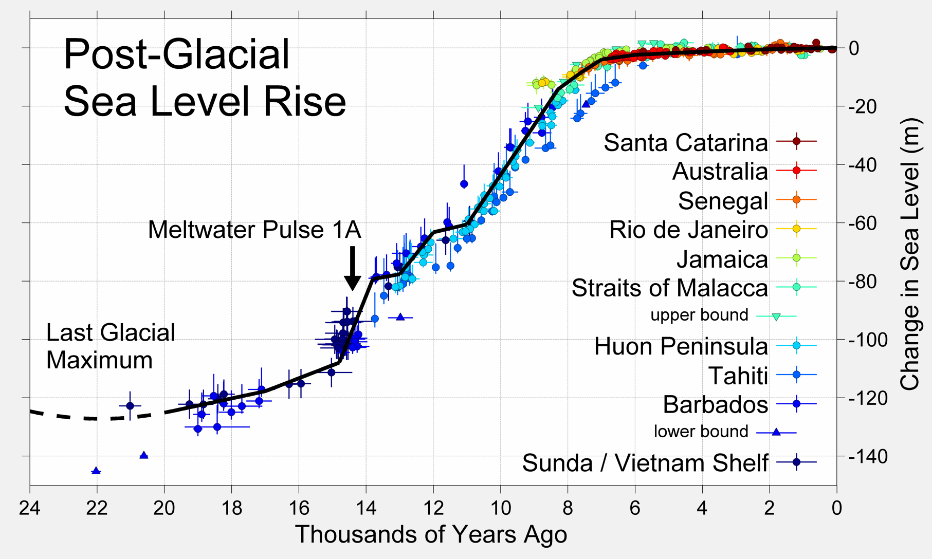
Chart for sea level since glacial maximum:
Post-Glacial_Sea_Level.png

As you see the glacial melt ended about 8k years ago, just before rise of civilisations and first cities. Actually the highest sea level (extra 2 meters) was during Holocene Optimum. Therefore it is extremely hard to conclude that rising of sea level submerged any ancient city. Most likely tectonic rise and fall of the ground caused sinking of some coastal cities. One of the best example is ancient Alexandria, where due to an earthquake ground went way lower submerging the city in the sea.
 
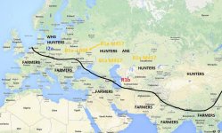
I think it all started from something like this, as per map below, just before IE conception 6 thousand years ago. We see a strong divide between Farmers and Hunter-Gatherers. Farmers pushed all HGs North to forests, steppes and semi deserts, and took the best grounds for their crops. Black line marks the approximate divide between farmers and hunters. I believe R1a M417 already gave L664, the rest of M417 sits Pontic Steppe just about to become farmers and IE, before Z93 and Z283 split.
Eurasia Farmers-Hunters.jpg
 
The sheeps of Scottland are grazing the grass for thousands of years and look, grass is still growing there. The problem is that the rain stopped falling over Tarim Basin.

In the temperate zone global winds blow from west to east so UK gets a lot of rain as moisture from the Atlantic deposits rain over the mountainous Scotland (the Highlands). The air by the time it reaches Central Asia has become dry as the moisture has been depleted passing over the Alps, Urals, etc. The gradual depletion of the glaciers in the Tien Shan mountains also slowly dried the rivers that trickled into the Tarim Basin. The lakes in the Tarim Basin are gone. It is simple Geography.

We know very little about the Sea Peoples but they seem to have found some tactics to get around the war chariots.

The Sea Peoples were possibly the indigenous Europeans Haplogroups I, G and E driven out of France and Spain by the Haplogroup R1b mainly. They were refugees looking for land in the coastal areas of the Mediterranean. There was also a war in Anatolia. These refugees provided manpower to the Phrygians who revolting against the Hittites and Mittani. Anatolia is mountainous so chariots were useless there. The Sea Peoples destroyed the Hittite Empire came around Levant to invade Egypt. They failed but took over the Levant. Just my hypothesis.
 
I'd like to make a point regarding the Tocharians: as far as the geographic proximity goes, one would indeed assume that Tocharian should be closest with the Indo-Iranic languages. But as far as relationship inside the Indo-European languages goes, the Tocharian branch is closest with the Indo-European languages on the western periphery, especially Celtic and Italic.

I might add, by my observation none of the rival theories of the Kurgan hypothesis do satisfiably explain the presence and position of the Tocharian languages. Actually, I would say that - ironically - the hypotheses are tendentially highly Eurocentric in that regard.
 
Can you please explain to me why people living in Anatolia would migrate east of the Caspian Sea in order to reach an area north of the Black Sea? Goga mentioned that but didn't explain it when asked. And, to be honest, I think that idea is silly.


I haven't been ignoring your question; it's just that I haven't yet come across the precise answer. I'm skipping around in the Grigoriev book to see if I can find out how he addresses the issue, but haven't found it in the limited time I've had available. Then I'll see if I can quickly find it in the Gramkelidze papers. (Grigoriev locates the urheimat in northern Mesopotamia, btw, not the Armenian highlands, and earlier than that 4,000 B.C. date, (6,000 B.C.) which seems very problematical, although I don't want to be dogmatic about it because I haven't read the whole section yet.

Off the cuff, I would say that some of these Near Eastern urheimat theories do see a movement west, one which would account for the Anatolian branch. They do, however, see a big group moving counter clockwise around the Caspian quite a bit later.

My initial thought was that the route through the Caucasus is obviously a difficult one, so I can see why that wasn't the chosen migration path; this is a refuge area for a reason. It seems to be that the only easy route is over a narrow strip on the east side of the mountains.

As for why the eastern route was preferred by this later group of people, rather than another movement west, I thought that by the time of the move, the way west might have been very densely populated given that it was the heartland of the Neolithic, and so offered no room for expansion. Or, I wondered whether because of climate change the way east suddenly became attractive at that point.

These seem like such simple things to research that the fact that they aren't part of the conversation probably means these ideas didn't pan out, but if I find out anything interesting, I'll post about it.

I don't know if you've had a chance to watch Professor Mallory's talk on the Tocharians linked to upthread. Anyway, you'll no doubt be pleased to discover that he seems to share your scorn for this end run around the Caspian idea. He calls it this theory that they were wandering around in Central Asia. :) The comment is at about 1:00 into the youtube video.
 
I shouldn't have called the "around the Caspian to get to the northern Pontic" idea silly, since I don't know what it was based on. But it does seem to be the difficult way of doing things. I think that if going through the Caucasus wasn't an option, it would have been more because of who was living there at the time than because of geographic difficulties, but I do think the area east of the Caspian might have had some folks living there too. And if the way was clear for people to migrate around the Caucasus, why would they have turned north, then west? If they could migrate into Iran, why not stay there? Or maybe just go north. If they were worried about running into other people, they would have had that same problem on the steppes, to a greater or lesser degree during different time periods.
 
R1a ? branch from Ukraine/Kurgan region reaches Anatolia with Hittites 1700.BC? Oldest attested Indo-European language.
Hittite_Chariot.jpg


Coach driver 2000 B.C.E. Harappa, Indus Valley Civilization R1a branch spread from Ukraine Kurgan/Andronovo region to Indus Valley?
Oldest attested Indo European Vedic Sanskrit related to Avesta and perhaps Mede ancient but extinct.

Coach_driver_Indus_01.jpg

[video=youtube;4jHsy4xeuoQ]http://www.youtube.com/watch?feature=player_detailpage&v=4jHsy4xeuoQ[/video]

Three regions posted in above diagram/lecture to discredit Anatolian theories. Complete vocabulary for vehicular cart/chariot- Iranian, Indic and Tocharian. R1a from Kurgan/Andronovo ?

Maciamo's vision: and rough time frame for R1a in Iranian Indic and Tocharian excludes Hittites.


R1a_migration_map.jpg

http://www.eupedia.com/europe/Haplogroup_R1a_Y-DNA.shtml


[/QUOTE]

Andronovo chariot 2000 B.C. R1a branch?
Tocharian chariot B.C ? R1a branch ?
Indic chariot 2000 B.C pulled by oxen R1a branch?
Iranian chariots and R1a branch?
Tocharian carts chariots? Tocharian R1a ? Tocharian language according to some posters, Italic/Celtic connection?

Does the spread of R1a/ language and cart-chariot match with known archeological finds?

I think there is a flaw in the timeline and physical evidence of R1a and chariots and horse in Indic region and Tocharian, to demolish Kurgan/Ukraine Andronovo chronological spread of R1a.
 
The Tocharians had to climb over one of the highest mountains in the world, Pamir and Tien (Heaven) Shan (Mountain) Mountains, to get to the Tarim Basin so they abandoned their wagons and horses. Central Asia was a different place than it is today. It was lush and the ice from the arctic and mountain glaciers provided lots of water in the summer. The herders destroyed their habitat as the bigger the herd the richer you were. The large herds consumed the grass and goats were the worst as they ate up everything including saplings thus destroying forests. With the browning of Central Asia it got hotter and dried the land and climate change occurred.

The Tocharians didn't cross the high mountains, they came into the Tarim Basin through the Dzungarian gate.
I guess they abandonned charioots because the lifestyle in the Tarim Basin was not the same as on the steppe.
 
I shouldn't have called the "around the Caspian to get to the northern Pontic" idea silly, since I don't know what it was based on. But it does seem to be the difficult way of doing things. I think that if going through the Caucasus wasn't an option, it would have been more because of who was living there at the time than because of geographic difficulties, but I do think the area east of the Caspian might have had some folks living there too. And if the way was clear for people to migrate around the Caucasus, why would they have turned north, then west? If they could migrate into Iran, why not stay there? Or maybe just go north. If they were worried about running into other people, they would have had that same problem on the steppes, to a greater or lesser degree during different time periods.

I don't think they went around the Caspian, simply because there is a big desert east of the Caspian, not possible to cross without horses or camels.
 
[
Andronovo chariot 2000 B.C. R1a branch?
Tocharian chariot B.C ? R1a branch ?
Indic chariot 2000 B.C pulled by oxen R1a branch?
Iranian chariots and R1a branch?
Tocharian carts chariots? Tocharian R1a ? Tocharian language according to some posters, Italic/Celtic connection?

Does the spread of R1a/ language and cart-chariot match with known archeological finds?

I think there is a flaw in the timeline and physical evidence of R1a and chariots and horse in Indic region and Tocharian, to demolish Kurgan/Ukraine Andronovo chronological spread of R1a.
Listen to this, it should answer your questions:
http://www.youtube.com/watch?v=HliaR2Ep24s
 
Judging by Li et al 2010 the migration of the Indo-Europeans (Tocharians/Saka) into the Tarim basin app. occurred at least ~1900BC (early Bronze-age);

Li et al 2010 - http://www.biomedcentral.com/1741-7007/8/15
'Based on analyses of human remains and other archaeological materials from the ancient cemeteries (dated from approximately the Bronze Age to the Iron Age), there is now widespread acceptance that the first residents of the Tarim Basin came from the West. This was followed, in stages, by the arrival of Eastern people following the Han Dynasty [1,2].'

During the Han dynasty there was however a back migration/invasion into Graeco-Bactria (Strabo XI/VIII) which later turned into the Kushan Empire (>Kingdoms); The Tocharians of Greek-Roman history (Strabo XI/VIII / Ptolemy VI / Justinus Epit. XLII Prol. XLII) are identifed with the Yuezhi [Yüeh-Chi] of Chinese history (Zhang Qian preserved in the Hanshu history and Sama Qian's history); The brief story goes that the Xiongnu of Cahnyu Modu defeated the Yuezhi and pushed them westward as Strabo relates of an entire confederation in XI/VIII 'They are all for the most part nomads. But the best known of the nomads are those who took away Bactriana from the Greeks, I mean the Asii, Pasiani, Tochari, and Sacarauli, who originally came from the country on the other side of the Iaxartes River that adjoins that of the Sacae and the Sogdiani and was occupied by the Sacae' and Justinus in Epit. XLII relates how the Parthian king Artabanus [II] was killed in battle against the Tocharians and Bactria became later known as Tokharistan; Bactrian/Kushan-Bactrian (Indo-Iranian/satem) still remained the official language in [50BC-650AD] in Bactria/Kushan (R.N. Frye p.458 The Fall of Graeco-Bactrians: Sakas and Indo-Parthians) whereas Tocharian [A/B] was a centum Indo-European language still in use by the 6th cen AD in the Tarim Basin (J.P. Mallory p.591 Encyclopedia of Indo-European Culture);
 
Listen to this, it should answer your questions:
http://www.youtube.com/watch?v=HliaR2Ep24s
Problems I have.Anthony shows Egyptian, Tut's burial chariot's. Tut's tested ydna has never been made officially public after 3+/- years. Wagon and chariot were such a fast traveling technology that he cannot determine the start and or direction of spread. 200 burial's in Steppe with chariot in kurgan. The question I have how many times is this burial technique [Kurgan buried chariot and or horse]mentioned in Vedic Sanskrit texts? How many on these types of burials are found in Northern India. How many of these types of burials are mentioned in Tocharian and found in Tocharian kurgan? How many of these types of burials in Medes, Mitanni, Hittites? In short, the migration routes of R1a Indo-European and burial methods are all different, can you prove otherwise? Kung Tut might be an exception.
There is also something very perplexing in this video at 59.15 about the spread of horses coming from Iranian plateau 1900 B.C. Look how they show there chariot, with oxen. Were they replaced by horses from Iranian plateau from Andronovo?

Coach driver 2000 B.C.E. Harappa, Indus Valley Civilization
Coach_driver_Indus_01.jpg
[/QUOTE]
 
I don't think they went around the Caspian, simply because there is a big desert east of the Caspian, not possible to cross without horses or camels.

I question how much archeological evidence there is of such a migration. Based on what I've read, I think it happened the way Maciamo's map indicates, with migration from the steppes into Central Asia, then down from Central Asia into Iran. For some reason, some people can accept the idea that Turkey wasn't always Turkish but find it difficult to accept the idea that Iran wasn't always Iranian. But Central Asia was clearly Iranian as it emerged into the historical period and I think the movement was north to south, not south to north.
 
Problems I have.Anthony shows Egyptian, Tut's burial chariot's. Tut's tested ydna has never been made officially public after 3+/- years. Wagon and chariot were such a fast traveling technology that he cannot determine the start and or direction of spread.
Anthony claims that we can't pinpoint origin of a wagon. However if it comes to a proper chariot he insists, based on archeology, that it spreads prof steppes to South Asia, and wherever it spreads we can find Indo-Iranian cultures around. Also spread of chariots goes hand in hand with spread of domesticated horse, which doesn't exist in South Asia before 2,000 BCE. Mesopotamians had domesticated asses, and their name for a horse was "ass from mountains". Recent genetic study also place domestication of horses in Steppe.
In short, the horse, the war chariot, R1a Z93, and Indo-Iranians point to spread of IE from the Steppe to South Asia.

200 burial's in Steppe with chariot in kurgan. The question I have how many times is this burial technique [Kurgan buried chariot and or horse]mentioned in Vedic Sanskrit texts? How many on these types of burials are found in Northern India. How many of these types of burials are mentioned in Tocharian and found in Tocharian kurgan? How many of these types of burials in Medes, Mitanni, Hittites? In short, the migration routes of R1a Indo-European and burial methods are all different, can you prove otherwise? Kung Tut might be an exception.
I'm not familiar with burial methods of these cultures. Maybe someone can enlighten us here.


There is also something very perplexing in this video at 59.15 about the spread of horses coming from Iranian plateau 1900 B.C. Look how they show there chariot, with oxen. Were they replaced by horses from Iranian plateau from Andronovo?

Coach driver 2000 B.C.E. Harappa, Indus Valley Civilization
This is a very weird chariot indead. We have full wheels and is drawn by young bulls, and exceptionally long tongue (wagon-horse connecting long piece of wood) and long axles than it should, therefore it can't turn too fast or it will flip from the momentum. The man doesn't have any known weapon, but some sort of hook on a stick. I think it is used for some sort of sporting event. The chariot look like purposely made to be difficult to drive for this competition. Nevertheless it is a chariot, and let's deal with it as such.
I did some reading and it looks like the scientists have difficulty with dating this chariot to exact period. Your 2,000 BCE is at the earliest possible date. It might be as well dated at 1,750 or 1,500 as latest (as some do). In this case right in line with spread of horse and chariots from the Steppe. Also in 1.800 BCE Harappa declines and is pushed farther east. Interestingly it might coincide with Indo-Iranian invasion.
 
Mythology usually is used as a device to demonize the conquered. In the Rig Veda (Iron Age as black metal is mentioned in their weapons) the dark-skinned are demons of India and the Aryans from Central Asia with their god Indra vanquish the demons destroying their dam that was on the Indus river. The dam is a demon. Also in the Ramayana the southern indians are demons and are dark skinned with small noses and their demon god is in Lanka (Ceylon). This is a favorite device to justify their conquest. Look at the Leprechaun in Ireland were they the original inhabitants who were threatened as the Haplogroup R1b metal workers looked for metal mines or Gold?
 
Back
Top